
A Big Loop Over Mount Chocorua
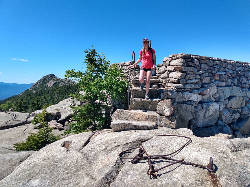
PHOTO: Bria on the stone steps of the remains of a fire lookout on Middle Sister, elevation 3,340 feet, with Mount Chocorua in the background. The Three Sisters form the northern ridge of Mount Chocorua and also have bare summits.

by Amy Patenaude
Outdoor/Ski Writer
Mount Chocorua is one of the most recognizable mountains in New Hampshire. It’s bare ledgy summit can be seen from near and far. In Tamworth, scenic Route 16 follows along the shore of Chocorua Lake. The view over its water to Mount Chocorua is the cause of many a car’s passengers to demand to stop and take a longer look. Maybe you’ve been on a boat on Lake Winnipesaukee and noticed it’s pointy rugged summit.
The view from the top of the mountain is wonderful too and it is no surprise that there are many trails to its summit. The busiest trails from the Route 16 side are the Liberty Trail and the Piper Trail. From the Kancamagus Highway the Champney Falls Trail is a winner. But no matter which trail you go there is just one short path up a steep rocky gully that must be climbed to reach the top.
Bria and I started early and we chose a loop over the mountain that included a lot of “new to Bria” trails. We started our hike at the Piper Trail parking lot, a fee area that requires the parking pass.

The day was hot and in our backpacks we carried a lot more water than usual. We headed up the Piper Trail and in about a mile we turned north to follow the Nickerson Ledge Trail. The views over to Mount Chocorua’s summit from the upper open steep ledges just before the trail intersects with the Carter Ledge Trail make it a worthy destination on its own (about 2 miles one way or just 1 mile from the White Ledge Campground).

The trail has some tricky places. There is one downward sloping ledge that would be more than tricky, dangerous actually, if it were a wet and slippery day. We used our rock climbing skills and zipped up the hot dry ledges.
We noticed that the trail maintainer has recently brushed the Carter Ledge Trail so all the brush was trimmed back nicely.
On top of Middle Sister there is a repeater station and the stone foundation that is the remains of an old fire lookout. We sat on the north side of the summit and enjoyed a snack while looking out at Mount Washington and most of the other peaks in the Whites–it’s a grant vista!

We continued to Mount Chocorua, passing by the first person we saw while hiking and the sun was hot. We connected to the Piper Trail and followed it over the ledgy slabs to the gully where the Piper and Liberty Trail meet. We scurried up it and there were maybe a dozen people spread over the summit ridge. We tagged the highpoint and left.
Down the Liberty Trail we went and we stayed to the right so we didn’t lose the trail in the open area. When we came to the Westside Trail, the bad weather route that bypasses the summit, we turned right on it and followed it back to the Piper Trail. This trail could really use some brushing. It was rather tight and grown in and on a wet day would really give one a good car wash.
We then continued down the Piper Trail. We passed by dozens of people headed up the trail. The trail is wide and well graded. We enjoyed plenty of fine views on our first mile of descent from the open ledgy areas.

About halfway down the trail we took the spur path up to Camp Penacook. The path is a rugged steep quarter mile climb to an shelter, tent site, privy. No one was around and we sat on the edge of the shelter and took a good long break. The water source is a small brook and it was barely trickling.
When we passed by the Nickerson Ledge Trail we knew we were almost back to the car. Our route was just 11 miles. And on a hot, hot day it felt like more.
To top off our wonderful day we stopped at Chocorua Lake and cooled off by taking a dip. The Chocorua Lake Conservancy has provided access to the water and there is a small parking area just before the Narrows Bridge on Chocorua Lake Road. (And later we got ice cream at the Sandwich Creamery.)
I love summer.
Have fun!


