
Anticipating Spring In NH 1745 – Danger Lurking In The Woods
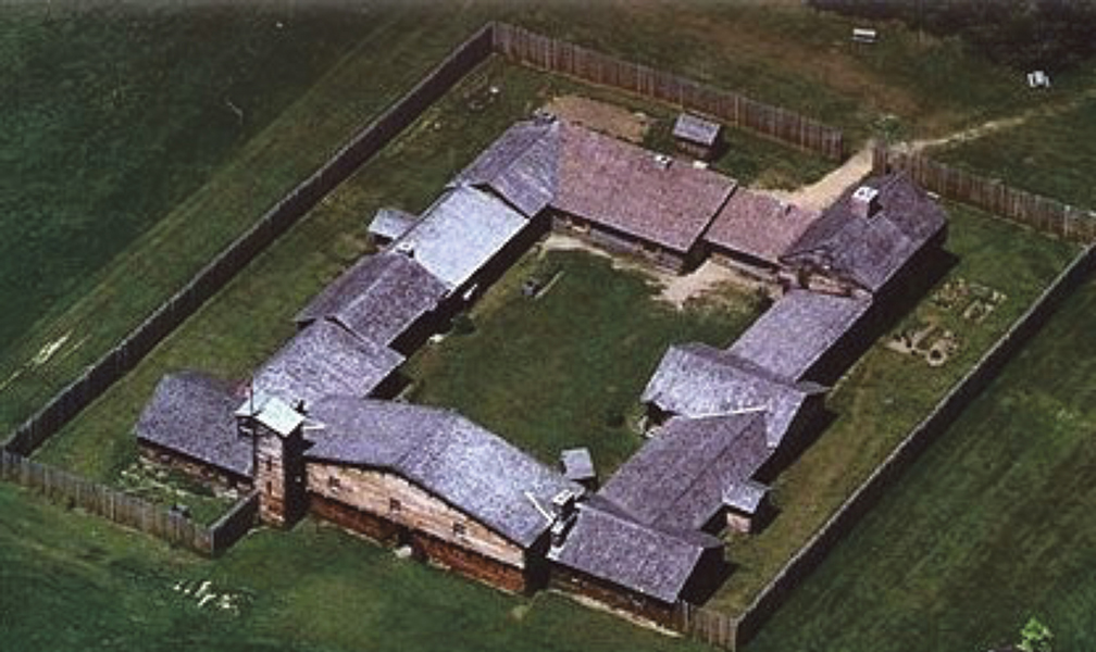
PHOTO: Fort #4 was first settled by 10 families in 1736 and the fort that became an important refuge was made up of six houses that were connected and included a tower with a view looking a long distance north and south on the Connecticut River. It is located in the present-day town of Charlestown, New Hampshire.


by Robert Hanaford Smith, Sr.
Weirs Times Contributing Writer
I imagine that about this time in 1745, as in 2021, and many years in between, that many New Hampshire residents were anxiously anticipating the coming of spring.
They were waiting for warmer weather which would hasten the melting of the snow and ice, and perhaps preparing to tap some maple trees to harvest the sweet sap which they could boil over fire as the natives had taught them, and produce maple syrup.
The 1745 settlers in New Hampshire were probably thinking about planting season and growing the corn that the natives had also introduced to them, along with other vegetables. They were, no doubt, looking forward to getting their cows out to pasture. There must have been some uneasiness, however, among the settlers in 1745 concerning the coming of spring. Certainly they had to be nervous about the coming season, and leery of allowing their children to roam in the woods. Not because of potential floods, or a late frost, or mud, or black flies, or bears emerging from their winter dens. It was something else that would return with the coming of spring: Indians!

Everett Stackpole in his History of New Hampshire wrote: “In the spring of 1745 the Indians began prowling the forests and appearing on the edges of the settlements. On the twenty-fifth of March they burned the house of the Rev. Timothy Harrington of Lower Ashuelot, now Swanzey.”
The Indian wars, though perhaps not given a lot of space in some history books, were hard upon life in the Granite State. According to Stackpole, Robert Mason, who claimed to be the rightful proprietor of New Hampshire, wrote the following in the year 1671: “New Hampshire is a place the best improved for land and most populated of any in those parts, abounding plentifully with corn, cattle, timber, and fish; and the people live generally very comfortably and happy; having a great trade to all parts, and store of shipping at their town, Portsmouth, which exports and imports yearly some thousands of tons of goods, of their own growth and foreign…”
In contrast, after the first Indian war, Simon Bradstreet wrote: “It is no small grief to us in Massachusetts to hear and see the miserable condition of our neighbors in New Hampshire; once a hopeful and flourishing plantation, but now in a manner undone, – no face of trade, nor care for anything else, their own vessels being afraid to come into their own ports, as some of them have declared unto myself.”


Remember that for most of the 1700s New Hampshire was a British colonial province. Great Britain was warring over land in their New World, with the Indians often siding with the French, and white land proprietors were at odds over the possession of land, some claiming they owned land because of grants from England, while others claimed it belonged to them because they bought it from the Indians. The Indians were feeling that their land was either being stolen from them or that they had not been fairly paid for it, while some white men insisted that the natives had no legitimate claim for land they were not using productively.
In 1736 Massachusetts granted four new townships along the eastern shore of the Connecticut River which would become the towns of Chesterfield, Westmoreland, Walpole, and Charlestown in New Hampshire. When the towns were granted (given) they were numbered as towns or plantations 1, 2, 3, and four. The Connecticut river was then an important transportation route for both white settlers and the native Indians. Forts and block houses were built to protect the settlers from Indian attacks and provide a military presence in the area. Plantation #4 was first settled by 10 families and the fort that became an important refuge was made up of six houses that were connected and included a tower with a view looking a long distance north and south on the Connecticut River.
According to the historian Stackpole a few settlers and Indians were killed or captured in skirmishes near the settlements in the summer and fall of 1745. With soldiers stationed at the forts along the river during the following winter the people passed the winter safe from harm. When March came 59 men were sent to Fort Number 4 to give extra protection in case of raids by the enemy.
On April 19, 1746 three men were driving a team of four oxen to a mill to purchase some boards when a band of about forty French and Indian warriors captured the men, killed their oxen, and burned the mill. The men were taken to Canada and eventually released.
That, however, was not the end of the violence along the Connecticut River in the Spring of 1746.

On the morning of April 23rd the Captain William Symes, commander of a fort at Upper Ashuelot (now Keene), was reading the Bible as others were leaving the fort to go to work and were attacked by a group of about fifty Indians. Ephraim Dorman was the first to be attacked by two Indians, but he escaped and sounded the alarm. John Bullard ran from the barn in an effort to reach the fort but was shot in the back and died. A Mrs. Clark outran a pursuing Indian and made it safely to the fort, but a Mrs. McKenney, who had gone out to milk the cows, was old and could not outrun the Indian who plunged a long knife into her back. Nathan Blake was captured and taken to Canada where he spent two years in captivity. A number of Indians were thought to have been killed by those firing their muskets from the fort.
Other ambushes occurred at or near the forts during the spring and summer of 1746 with more deaths and captures. As women from Fort #4 went out to milk the cows on May 2nd they were guarded by soldiers, but eight Indians were hiding in the barn and killed Seth Putnam. On May 24 a group of New Hampshire soldiers (called troopers by Stackpole) were ambushed as they visited the site where Seth Putnam was killed. Five troopers and five Indians were killed on that day, with one of the troopers, Samuel Farnsworth, one of the first settlers, being hit by “friendly fire.”
A dozen Indians and twenty men from Fort Dummer engaged in a battle near Colonel Hinsdale’s mill on July 3rd of that year.
Have you ever watched a western movie and wondered how there could be so much shooting with so few men being hit by bullets? That may be more realistic than we realize. In that July 3rd Hinsdale battle the only injury reported was that of Moses Wright losing two fingers.
Everett Stackpole wrote: “It is surprising how companies of troopers and Indians would shoot at each other for hours, and only a few would be hit. Old flint-lock muskets were not very effective.”
We can only imagine the struggles the settlers had in trying to establish homes in those days of such unrest and danger in New Hampshire when women risked their lives to milk the cows and children could not stray far from home for fear of being kidnaped, and the plight of the Indians in deciding whose side they would join.
Robert Hanaford Smith, Sr., welcomes your comments at danahillsmiths@yahoo.com