
Carrigain Notch & Mount Carrigain

by Amy Patenaude
Outdoor/Ski Writer
The mountaintops were hiding behind the clouds as I drove down Crawford Notch. I turned up Sawyer River Road and drove up the gravel road that is now narrow in a few places due to repairs made to re-open the road after hurricane damage but otherwise it was in good condition.
The air felt crisp and cool as I stood outside my car in the Signal Ridge Trail parking area. Bria and Jeremy arrived a few minutes later and we hit the trail sometime shortly after 8:30 am. We had hiked Carrigain together in the late spring but this time we were taking a more roundabout route to reach the summit. Our plan was to hike through Carrigain Notch and then up the steep Desolation Trail to the summit.
The hike begins along the bank of Whiteface Brook, the footing is rough in places but the sights and sounds of the cascading water are pleasant. The trail then leaves the brook and levels out until it crosses Carrigain Brook. Luckily the water was running low and it was an easy rock skip and a hop to get across.

Soon we left the Signal Ridge Trail and turned right up the Carrigain Notch Trail. The footing was nice and soft because it is much less traveled. In a little while Bria spied some good eating mushrooms growing on a log and we continued hiking. She wished out loud that she had brought her mushroom bag. I stopped and said I needed a drink and Jeremy said he did too. I dug into my pack and took out a large zip-lock bag and I emptied my lunch straight into my pack. I handed the bag to Bria and we urged her to run back up the trail and get those Oysters.


She gleefully went mushroom hunting and she returned with a full bag of white mushrooms. As we neared the height of the land we could see through and above the trees to the gray and reddish jagged ledges on the nearly vertical wall of Mount Lowell. Carrigain Notch is narrow between Vose Spur and Mt. Lowel. At the height of the land is the boundary for the Pemigewasset Wilderness and we would be in the designated wilderness area until we reached the Carrigain’s summit.
In a muddy area we noticed a perfect bear paw print. We saw a few more prints but we never saw the bear that made them.

The trails in wilderness areas are left rather wild or I dare say they are not maintained well. I don’t think well maintained trails take away from a wilderness experience. The old bog bridges have been left to rot away and will not be replaced, the spikes that held once solid logs in place are now hazards poking out of rotted wood and mud. The trail is narrower because the brush has grown in but the footbed of the trail is easy to follow and that’s good because the trail blazes marking the way have long been removed.

At the trail intersections of the Nancy Pond Trail and Stillwater Junction the new trail signs have spelled Carrigain incorrectly,
“Carrigan.” While we enjoyed the gradual grades, the lovely brooks and the secluded forest, we knew what lie ahead–the Desolation Trail.
The Desolation Trail is rough and steep and climbs 2,500 vertical feet in just under two miles. This trail is included on “The Terrifying 25” list. Check out the other 24 terrifying trails at theterrifying25.com.
This was Bria’s first time on this trail. Jeremy had done it before and I had hiked it too but it was a long time ago.
The trail starts out reasonably on old railroad grades and logging roads and then it just goes straight up. The steepest sections climb up over blocky vertical rocks and damp ledges. Right below a challenging section we took in our first long distance vista over to the cliffs on the side of Mount Willey and the clouds appeared to be lifting.
We chugged steadily up the mountain. There didn’t seem to be as many rock steps as I remembered but it was steep and rocky.
I asked Bria to guess how many people would be on the summit and she answered 12 and I guessed 8.
I knew we were near the top as soon as the grade gradually decreased and poof! We were on the summit and out of the wilderness area.
On top of the tower there were a couple people and a dog that didn’t want to climb back down the tower’s metal steps. As we began to climb the observation tower, a group of ten women arrived from the Signal Ridge Trail and a couple guys were sitting nearby eating. The summit was a busy place and both our guesses were low.

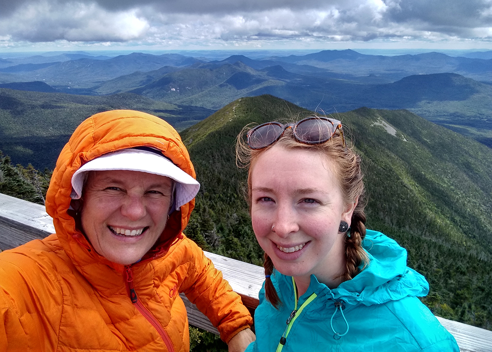
The clouds lifted and we were treated to a grand vista far and wide!
It was too chilly and windy on top of the tower. We climbed down and found a place to sit where we could look down over Signal
Ridge and far beyond while we ate our lunch. We had lucked out that the day had cleared and gave us grand panorama. I had a cheese sandwich instead of my usual peanut butter and jelly. Jeremy and Bria had leftover pizza and I was a tad jealous.
We hiked back down the Signal Ridge Trail and we stopped to take a few photos along the open ridge area. I think we only took one break on the way back. The surprising thing was that we didn’t see that many people along the way. Nearer the top we had met a few people about to summit but we didn’t meet anyone else until we crossed back over Carrigain Brook. This fellow went running past us at a fast clip.
Back at the car we all hustled to get home. We had a terrific day together and we were all happy to have lucked out with the weather.
Here comes fall and have fun!
Amy Patenaude is an avid skier/outdoor enthusiast from Henniker, N.H. Readers are welcome to send comments or suggestions to her at: amy@weirs.com.


