
Cherry Mountain Rainy Day Traverse
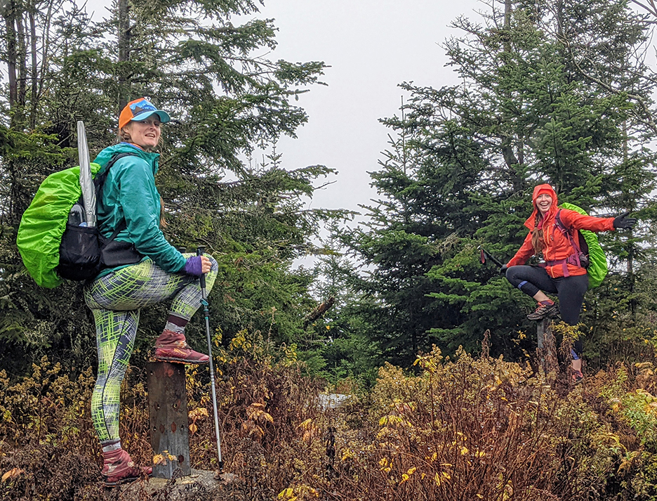
PHOTO: Danielle and Bria standing on the footings of the former Cherry Mountain Fire Tower on Mount Martha. Mount Martha is named after George Washington’s wife Martha.

by Amy Patenaude
Outdoor/Ski Writer
Cherry Mountain is a prominent mountain ridge located in the town of Carrol/Twin Mountain. Cherry Mountain’s highest peak, Mount Martha, is a former fire tower site and on the “52 with a View” hiking list. At the north end of Cherry Mountain’s ridge is the sharp pointy bump named Owl’s Head (not to be confused with the 4,000 footer Owl’s Head in the Pemi Wilderness). These peaks have wonderful outlooks with splendid views to the Franconia Range and the Presidential Peaks but not on a cloudy rainy day.
Danielle, Bria and I had hoped for better weather when we planned this hike but we did know the forecast wasn’t looking good. But if you don’t hike in the rain once in a while it will take forever to hike all the trails in the White Mountain Guidebook. They were gathering WMG redlines. I had colored my maplines long ago but I thought it would be fun to return to Cherry Mountain with them.
After we grabbed yummy breakfast sandwiches at YaYa’s in Twin Mountain we drove around Cherry Mountain Road to the height-of-the-land to the east Cherry Mountain Trailhead to drop off a car. Then we drove back to Route 115, aka The Cherry Mountain Highway, to the Owl’s Head Trailhead.

At the Owl’s Head Trail parking area there is a State of New Hampshire historical marker telling the story of the 1885 Cherry Mountain Slide that killed a farm hand and destroyed the Stanley Family farm.
Before we started I decided to put on my rain paints. It was 42 degrees and raining lightly. We all wore our rain jackets and Danielle stuck her umbrella in her backpack’s side pocket. The Trail starts out on private land, having been rerouted about 20 years ago. It wasn’t our imagination that for the first flat half mile we were not hiking towards the mountain but going around the perimeter of private property. The log bridges across muddy wet areas were really rotten so we did our best to rock hop and hunt for the driest places to step on. Most of the leaves had fallen off the trees and covered the mud making it nearly impossible not to misstep and sink into the black muck.
In about a mile we crossed Stanley Slide Brook and this is where the steep climbing really begins and it just keeps getting steeper. We hiked up into a cloud and the forest looked spooky. Bria pointed out some mushrooms to us but she didn’t gather any. At times the trail looked like it was covered with colorful confetti thanks to the fallen bright foliage.
On top of Owl’s Head we didn’t linger but continued down the beginning of Martha’s Mile to the ledges. Instead of whining about being inside a cloud, Danielle and Bria shaded their eyes with their hands and pondered their pretend view. They called out the names of some of the nearby peaks. Of course we couldn’t see more than a 100 feet in front of us and we enjoyed laughing at ourselves.


Scrambling down the steep ledges was the most difficult part of the hike. We just took our time and used our hiking poles to help keep us from slipping. The rest of the way across Martha’s Miles to Mt. Martha is quite pleasant. Grayish green wispy lichen hangs off the branches of the trees here. I’ve heard it called Old Man’s Beard and it isn’t Spanish Moss but it drapes the trees like it. During a short snack and water break I don’t recall which of one us decided we should have Moss-taches. We all took a piece and dangled the lichen beneath our noses. The silliness helps keep us warm. Danielle pointed out that it had begun sleeting. Thankfully it didn’t sleet long and returned to all light rain.
I learned from 1HappyHiker.blogspot.com that John Compton, who was the trail maintainer of Martha’s Miles for 15 years, shared the history of Martha’s Mile. It was a “lost trail” and a local man, Bill Nichols, reopened it in the mid 1960’s to connect the two peaks. Nichols then cared for the trail for 38 years. I also learned that Mount Martha is named for George Washington’s wife! When we arrived on top of Mt. Martha, elevation 3.573 feet, we checked out the old fire tower footings. The Cherry Mountain fire tower was first constructed in 1939 and was razed in 1982 and dismantled in 1989 according to FireLookout.org.

We didn’t stay long on top. By now we were wearing hats and gloves and our feet were pretty wet too. We took the spur path down to the Cherry Mountain Trail and headed down the east side of the mountain to get back to our car spotted on Cherry Mountain Road. The west side of the trail comes up from Route 1115.
This side of the trail is lightly used by hikers compared to the other side of the trail. It is longer than to reach the summit of Mt. Martha, 3.6 vs 1.7 miles and the east side is a wide snowmobile trail that is grassy and often muddy. But it does have more than a dozen nice bridges over small streams. We marched down the mountain just like we went up, we didn’t rest.
The hike was short of 7 miles, including our short breaks for silliness and nourishment, and took us just three hours. The cold was a good incentive to keep moving.
Back at the car we put on dry clothes and turned the heat up high. Since we really didn’t eat lunch we then went out for pizza. Now all of us have hiked every trail on Cherry Mountain but we found an abandoned trail that maybe we will snowshoe this winter. Yes, the days are getting shorter and winter is coming.
Have Fun.
Amy Patenaude is an avid skier/outdoor enthusiast from Henniker, N.H. Readers are welcome to send comments or suggestions to her at: amy@weirs.com.
by Amy Patenaude
Outdoor/Ski Writer


