
Lonesome Lake & Mount Kinsman
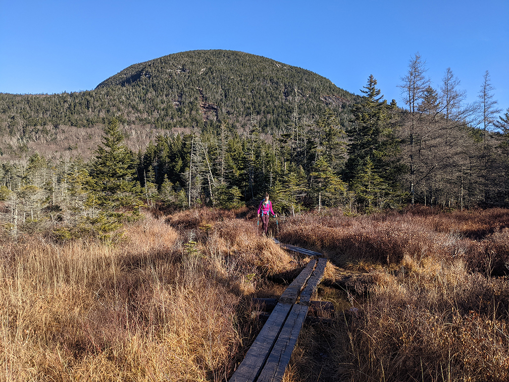
PHOTO: On the Around-Lonesome Lake Trail on plank walkways on the Northeast shore with big views of Copper Mine Col between the East Cannon Ball and Cannon Mountain. The views across Lonesome Lake are mighty fine and depending where you’re standing you can see Mount Kinsman and the Cannon Balls or the mountains of the Franconia Range. We even saw a big Trout in the Lake!

by Amy Patenaude
Outdoor/Ski Writer
Becca and I met just before 8 am at the Lonesome Lake Trailhead next to the Lafayette Place Campground on the southbound side of the Franconia Notch Parkway. There were still plenty of parking spots available.
After a couple rainy weekends in a row we were happy to see blue sky. We knew that the trails would still be wet from the rain earlier in the week and we were thankful we wouldn’t need raincoats on this hike.
The hike to Lonesome Lake climbs from the floor of the Notch up 1,000 vertical feet in 1.2 miles (an additional half mile to get to the other side of the Lake and the AMC Hut). The trail isn’t easy but since the distance isn’t too long to reach the lovely lake it is a favorite hike for people of all ages and abilities.
At the trail intersection we walked down to the Lake’s east shore. Its placid waters reflected the Kinsman Ridge just as if the water was a fine mirror.
We decided to follow the trails counter-clockwise around the Lake, still on the Lonesome Lake Trail. We then continued on the Around-Lonesome Lake Trail to the AMC Hut. The Lonesome Lake Trail actually goes past the north end of Lonesome Lake and ends at the Coppermine Col on the Kinsman Ridge Trail.


We didn’t stop at the hut but marched on past and began following the Fishing Jimmy Trail. The blazes are white on this trail because it is a section of the Appalachian Trail. I think it is one of the most difficult sections of the AT because it is always wet and slippery and steep. The trail goes up and down and crosses a few streams and has sections where the stream flows down the middle of the trail.
In the streams there were lots of piles of whitish copperish colored foam. It is caused by the hard rains mixing up organic material with the water and it is very airy and fluffy. We played with it, blowing it to disperse like bubbles.
Becca and I thought it was interesting seeing that trail maintainers long ago cut the steps into the granite slabs and used some of the rock pieces to build stairs. There are also slippery wooden steps that we debated if it would be better not to have them at all. We both agreed iron bars would be much better. Maine and Vermont use iron rungs and they aren’t slippery.
When we reached the junction with the Kinsman Ridge Trail we took a break. We ate snacks and admired the view. A few young men went by us and we followed them towards the summit of North Kinsman. We chatted with them and learned this was their first time up the Kinsmans.
“The true summit of North Kinsman is a pointed boulder on the east side of the main trail, 30 yds North of the outlook spur” quote from the White Mountain Guide.
We tapped our hiking poles on top of the highpoint, pointing out the pointy boulder to the guys.
Becca and I continued on to South Kinsman, just a mile away. This section always feels quick, it doesn’t go down too far and doesn’t feel like it climbs too high.
The panorama view from the ridge filled our eyes as we hiked across to the south knob and the big rock cairn. It was breezy and a little chilly. But no snow or ice yet but I am sure there’ll be some next week!
We spent a few minutes admiring the view from the south knob but then we retraced our steps back to the north knob where we were more protected from the wind. Here we ate an early lunch, I had a Swiss cheese sandwich!
On our way back to North Kinsman we started meeting lots of people on the trail. North and South Kinsman are #28 & #22 on the NH 4,000 Footer List.


We continued on down the Kinsman Ridge Trail and turned off down the Fishing Jimmy Trail. We did our best not to tumble down the trail and to stay on our feet. We kept meeting lots of other hikers on their way up.
When we reached Lonesome Lake we took the Cascade Brook Trail and completed circling the Lake counter clockwise before heading back down to the Notch on the Lonesome Lake Trail.
We met dozens and dozens of people headed to Lonesome Lake. Bright white sneakers appeared to be the footwear of choice for day hikers to the Lake. It was a perfect day to visit the lake.
When we returned to our cars the lot was full and overflowing. Apparently there are no longer any parking rules for late arriving hikers.
Our hike out and back over North and South Kinsman was about 10 miles. I am betting it is the last one without mirco-spikes or even snowshoes this year!
I am ready to get out my skis,
Have Fun!
Amy Patenaude is an avid skier/outdoor enthusiast from Henniker, N.H. Readers are welcome to send comments or suggestions to her at: amy@weirs.com.