
Magalloway Mountain
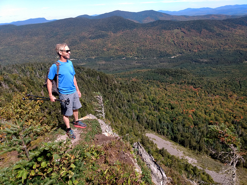
PHOTO: Charlie on the edge of Magalloway Mountain’s east cliff at the end of the Overlook Trail. The short spur trail begins at the mountain’s summit behind the old fire warden’s cabin.

by Amy Patenaude
Outdoor/Ski Writer
Yes, it is a long drive to hike Magalloway Mountain. It is almost 2.5 hours from Franconia and that gave me a lot of time to think about the geography of Pittsburg.
Magalloway Mountain is way up north in Pittsburg, New Hampshire–almost Canada, the very top of the State. The Town of Pittsburg is New Hampshire’s most northernmost town. I double checked this too–it’s the only New Hampshire town that borders Canada, Maine and Vermont. Since it contains the headwaters of the Connecticut River it is also the only town that has land west of the River and the only town to share a land border with Vermont. Pittsburg is 291.2 square miles, the state’s largest town in area. For comparison, the second largest is Lincoln with its 130.9 square miles.


Up Route 3 we went and just north of the First Connecticut Lake we turned right onto Magalloway Road, a gravel logging road. We didn’t meet any logging trucks but we did pass by a few cars that kicked up blinding dust. The road was in surprisingly good condition when compared to other pot-holed trips I have previously made here. Just past 5 miles in at the “Tower” sign we turned right onto a narrower and rougher road. The tower road is passable with a passenger car with slow and careful driving. There are a few icebergs (pointy high rocks) that should be avoided. The road dead-ends in three miles at the trailheads.
The parking area was nearly full so a few others had the same plan to see the North Country’s early fall colors from above.
Charlie and I headed up the Bobcat Trail. Since we have been here before we knew it started on the right just before the parking area. Recent work has been done and it’s not quite finished. There is a new kiosk but it has no information posted and there were no trail signs. But there was a signpost next to the two-log bridge that crosses the ditch at the start.
The trail climbs up from the road and it’s steep with a few short breaks. Halfway up there is a nice viewpoint with a view over the forested lands to the blue waters of the First Connecticut Lake. Thanks to the hard working trail maintainer the blow-downs had been recently cut to clear the trail.
The Bobcat Trail joins the Coot Trail 2/10ths from the summit and from here it is an easy walk on the wide trail to the Fire Lookout Tower. Since there were a few people up on the tower we decided to check to see if there was any water in the spring.

The path descended steeply and there were a few blow-downs with worn paths around and over them. It was a good tenth of a mile down to the dry rock lined hole. Not a drop of water to be found.
People were still up in the tower so we went to the Outlook Trail, I didn’t see a sign but it is obvious and starts right behind the locked up fire warden’s cabin. The path goes downhill and has three good outlooks but the furthest offers the best views. From here we could look up and see the upper part of the cliff that we were standing on and down at the broken rock/talus slope at the foot of the cliff.
When we got back to the summit it was our turn to go up the tower. We had enjoyed big views from the cliff but from the floor just below the locked cabin the grand panorama filled our eyes. Yes, we could see deep into three States and Quebec. We could even spy Mount Washington. I pointed out nearby Diamond Ridge and Stub Hill–Pittsburg’s highest point that is almost three hundred feet higher than Magalloway. The big landscape is wild with few of mankind’s marks to be seen.
Waiting below were three men. Two dashed right up as we stepped off the last step. The third was hesitant. He told us that they had come to relive what they had hiked together as children and he feared heights. We told him the view was clear and it was worth trying to go up. After a moment of reflection he turned and slowly climbed the tower’s steps and joined his friends.

We took the Coot Trail down. The Coot Trail was the grown-in old fire warden’s road and “Wow” is all I can say. A big excavator went wild and blew it open and surely some blasting was involved too. The big machine built a number of giant rock cairns alongside the trail that reminded me of Whistler Olympics.
The Coot Trail is now wide and has deep water bars. I bet the footing would be greasy if it were at all wet. The snowmobilers are the ones benefiting. Maybe with enough snow the groomer will be able to make the steep climb and the snowmobilers will have no problem if they meet someone coming the opposite direction. In time the trail will pack out and the hiking will get better.
Thanks to the Gazetteer we did some adventure driving that led us to a class six road off of Route 145 in Stewartstown. We had hoped to find a new way to get to Colebrook but after the four-wheelers came by we decided to turn back. Along our way back we went down another gravel road that led to the North Hill Cemetery where Metallak is buried. On Route 145 there is a historical marker honoring his memory.
Further south on Route 145 we passed by Beaver Brook Falls in Colebrook. The Falls only had a trickle of water flowing. Isn’t a waterfall with no water just a cliff? I had a lot to think about on the way home.
Have fun.
Amy Patenaude is an avid skier/outdoor enthusiast from Henniker, N.H. Readers are welcome to send comments or suggestions to her at: amy@weirs.com.