
Moat Mountain Trail – South & Middle Peaks
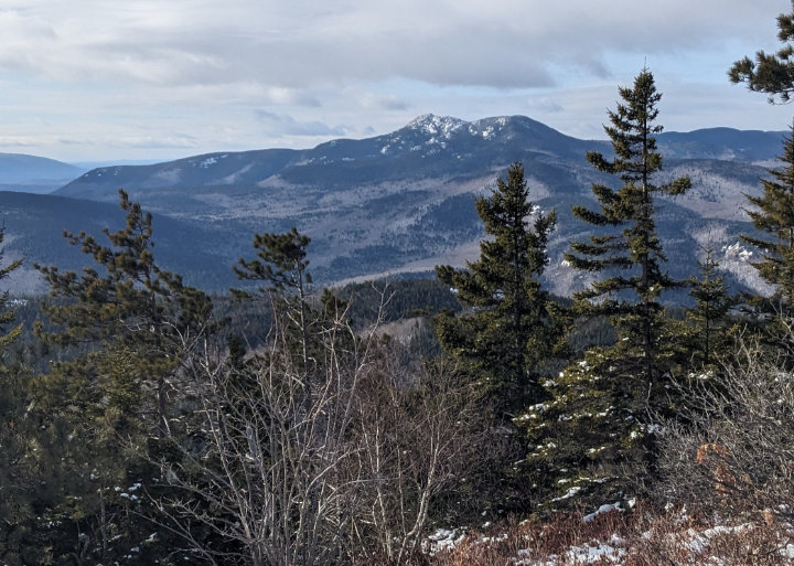
PHOTO: A grand view of Mount Chocorua from near the summit of South Moat Mountain. Moat Mountain has three peaks, South, Middle and North and the ridge runs from north to south. The Moat Mountain Trail stretches between Passaconaway Road in Albany to Diana’s Bath in Bartlett; the mountain is west of North Conway. South Moat Mountain, elevation 2,772 feet and North Moat Mountain elevation 3,203 feet are on the 52 With-a-View New Hampshire hiking list.

by Amy Patenaude
Outdoor/Ski Writer
“Moat is always a winner!” My hiking pal Zachary texted back to me after I told him I was thinking of heading to the Moats.
It was three years ago we snowshoed up North Moat. He dashed back down and I continued on bushwhacking over to Big Attitash. I was closing in on my winter New Hampshire highest 200 list. I recall he went off to do another nearby mountain too.
Like that day three years ago it was cold and windy and snow flurries were moving around in the White Mountains. As I drove to the south terminus of the Moat Mountain Mountain Trail it was snowing at the top of Crawford Notch. The forecast called for a mostly sunny day but I wasn’t believing them as the wind pushed my car around.

I was glad I knew where I was going because Google directions were crazy–it directed me to go park on the side of the Kancamagus Highway and ford the Swift River to the trailhead. The Moat Mountain Trail is easily reached on the other side of the river on Passaconaway Road but only from the east from West Side Road. Access from the Albany covered bridge is gated in the winter and the west side of Passaconaway Road is not open in the winter. It isn’t unusual for cell phone directions to be bad in the mountains. It is smart to follow the directions in the AMC White Mountain Guide.
The good news was that the trailhead parking lot is plowed in the winter but the bad news is that it was an ice skating rink. There was one car in the lot when I arrived at 8:30 am.

My winter backpack was heavy with extra warm clothes and mittens. I also carried micro-spikes and snowshoes. I didn’t know how much snow I might find high up on the ridge between the peaks. My boots have good soles and I decided to go bareboot since it looked like once I got on the trail I could avoid ice.
The first mile of the trail to the bridge that crosses over Dry Brook was mostly bare ground with some avoidable ice patches. Although descent down to the brook was mostly ice I didn’t feel like putting on my spikes for just a few minutes so I slowly and carefully made my way down, every step thinking why didn’t I put my spikes on?
The gradual grades turned steep and the rocky trail became a path of dry rocks poking out of snow and ice. I rock hopped along. Here I met a bundled up fellow smartly wearing spikes coming down the trail. We exchanged greetings and chatted a moment and I learned that he was returning from Middle Moat and enjoyed some good views and sunshine. I also found out I could have left my snowshoes in the car.
A few moments later I spied a speedy fellow coming up behind me. Before he passed by me he told me he lived locally and that he climbs South Moat often and he was wearing spikes.

When I came to some long ice flows I decided to take the longer route and bushwhack around them. Higher up the mountain the snow was squeaky cold packed and made for a nice sidewalk.
As I neared the open summit of South Moat the fierce wind hit me hard and made my eyes water and my nose cold. I pulled my hood extra tight. I could barely make out Mount Cranmore Resort’s snow covered ski trails and further north it was dark and snowy looking. To the northwest it was dark and cloudy too. To the southwest and south the sun was poking through and I enjoyed a grand view of Mount Chocorua. I was in the sun too on South Moat.
I continued on the ridge towards Middle Moat. The wind and snow had nearly filled in the tracks of the earlier hiker. I couldn’t see anything past North Moat and sometimes the clouds made it hard to see. North Moat is only two miles away. It sure was dark. I hiked quickly to the open ledges of Middle Moat. I stayed on the trail and hit the north bump near the trail and then I back tracked a little and went west off the trail to tag the actual highpoint of Middle Moat. I stood there looking down through the swirling dark clouds and yet it was mostly sunny right where I stood.

I retraced my steps back to South Moat, hiking towards the sun. Back in the woods the cold
wind couldn’t get at me. Again I avoided ice on the trail by bushwhacking around it. At one point I was well below the trail and above me I saw a couple with a dog walk by and they didn’t see me.
The hike back to the car went by fast. I stayed warm and stayed on my feet. I felt like a winner picking a hike that wasn’t in a dark cloud.
Have fun.
Amy Patenaude is an avid skier/outdoor enthusiast from Henniker, N.H. Readers are welcome to send comments or suggestions to her at: amy@weirs.com.


