Moose Mountain & More: Appalachian Trail Tramping

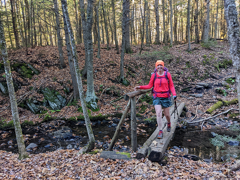
PHOTO: Wear orange and bright colors because it is hunting season! Bria on a log bridge crossing Mink Brook on the Moose Mountain Trail, it is part of the Appalachian Trail in Hanover. The point to point traverse of the Moose Mountain Trail over Moose Mountain’s South and North Peaks is 5.6 miles with 1,400 vf of climbing. Yes she is wearing shorts in November, the weather has been so warm and nice.

by Amy Patenaude
Outdoor/Ski Writer
This was the second Thursday in a row that I accompanied Bria while she finished up redlining the Moosilauke Region chapter in the AMC White Mountain Guide. This requires hiking the Appalachian Trail from Moosilauke to the crossing of the Connecticut River and all the connecting trails and more. She needed to hike everything in the Hanover-Lyme area so we went hiking.
We rode together so we had one car. I dropped her off at the Hanover Co-op and I drove around to East Wheelock Street and we hiked towards one another. We ran into each other at the Velvet Rocks Shelter. The trail and shelter is named for the nearby moss-covered rocks and ledges. Instead of continuing north on the AT we started redlining in earnest—down the Ledyard Link, a roadwalk, up an unnamed path back to the shelter, we looped down to the spring and back down the Shelter Loop.


I continued north on the AT with Bria and then we followed the Trescott Spur down to the road. At the road Bria turned around and retraced her steps up the trail and I walked down the road back to my car. I then drove to the north end of the Velvet Rocks Trail and walked south to meet her. When I met Bria I backtraced to the car with her.
The tramping was fun, not too much climbing and the weather and the views through the leafless trees deep in the forest was enchanting. Since the day was only half over we decided to tackle the south side of Holt’s Ledge.
We hiked in shorts and the sun was almost too hot!
The out and back to Holt’s Ledge from Goose Pond Road was splendid. It was so pretty. We saw a single bright gold Larch beaming on the far side of the beaver pond and new wood chips proved the beaver was busy. We climbed over 1,200 vf and we enjoyed a grand vista that reached from Mount Cardigan and the Waterville Valley area mountains to nearby Winslow ledge & Smarts Mountain. I think Bria tackled about 9 miles of new to her trails but it took almost 12 miles of hiking to get it.
The following Thursday we dropped a car off at Goose Pond Road at the AT crossing and then drove around to the AT crossing on Three Mile Road. We hike 5.6 miles point to point over Moose Mountain’s South and North Peaks climbing over 1,400 vf.
Again the weather was almost too good to be true. The morning was cold but it warmed up quickly. Bria stuck with shorts but I wore pants.
Bria was quick to spot a big Barred Owl land on a branch tight to the Beach Tree’s trunk. The Owl blended in with the tree. It took me a while to see him. She told me that her husband tells her that she has Moose eyes because she sees things that others don’t in the forest. That’s funny, because moose eyes aren’t right for good eyesight. Moose are incredibly near sighted and otherwise don’t see well but they have a great sense of smell and hearing. Really.


Moose Mountain is the first taste of New Hampshire’s mountains for Northbound AT hikers.. The trail is a long green tunnel between Killington, Vermont to Hanover and the wide mountain view from Moose Mountain’s South Peak lookout must be a welcome sight. We enjoyed the view while we ate Mom’s oatmeal cookies and pointed out the mountains Cardigan and Ragged.
The ridge walk between the peaks is rolly and nice. The first bump is the home of the Moose Mountain Shelter. We hiked the shelter loop and checked out the privy–there’s a moose on the door. There is also a nice bench facing the big view smack in front of the shelter. The view has grown in and the trees should be cut to save the shelter’s view.
Walking in the crunchy leaves along the long ridge was pleasant and the miles this day went by so quickly. Descending the last mile felt extra steep because we were careful not to slip on the trail so deeply covered with leaves.
When we reached the car we jumped in and drove back to get Bria’s car. Then we both drove our cars to the Dartmouth Skiway/Holt’s Ledge Trail and dropped her car again. Then we drove up Dorchester Road and parked at the Smarts Mountain Trailhead to do the Skiway Trail, the two mile piece she was missing.
The only time I did this piece of the AT I was backpacking in hard pouring rain. The one thing I could recall about the trail was passing by a granite post marking the AT milage. It took us less than an hour to get this important redline connecting a long section of the AT for Bria.

But Bria still has to go back to Hanover one more time. She still needs to walk the mile on the AT from the Connecticut River, through town to the Co-op. She can do that anytime, maybe this winter after skiing the Dartmouth Skiway.
Happy Fall, Have Fun.
Amy Patenaude is an avid skier/outdoor enthusiast from Henniker, N.H. Readers are welcome to send comments or suggestions to her at: amy@weirs.com.
