
Mount Monadnock: Marlboro Trail And Monte Rosa
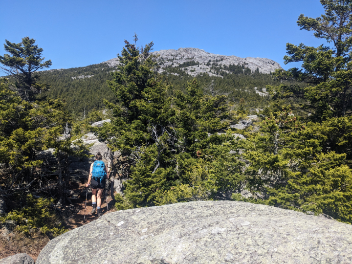
PHOTO: Becca leaving Monte Rosa, a sub-peak on the southwest shoulder of Mount Monadnock. From here the summit of Mount Monadnock is high above her and three quarters of a mile away. Mount Monadnock is the second most frequently climbed mountain in the world with 125,000 hikers tramping up its trails each year. Visit NHStatePakrs.org to learn more about the nearly 40 miles of trails and campgrounds in Monadnock State Park.

by Amy Patenaude
Outdoor/Ski Writer
If you hike mountains in New Hampshire there is a good chance you have hiked or will hike Mount Monadnock. It is just too hard to resist. The mountain is located just southeast of Keene in the towns of Jaffrey and Dublin. Monadnock is a big beautiful mountain with an immense bare summit, elevation of 3,165 feet.
Mount Monadnock is special because it is nearly 1,000 feet higher than any other mountain within 30 miles. Mount Monadnock’s 2,186 feet of prominence ranks 9th on the New Hampshire prominence list.
The word monadnock means isolated mountain. According to the New Hampshire Forest Society’s website the name Monadnock is an Abenaki name meaning “mountain that stands alone.” The Forest Society owns the majority of the land on the mountain, more than 4,500 acres and it is leased to the State of New Hampshire and operated as Monadnock State Park.
But here’s an impressive fact about Monadnock. It is the second most frequently climbed mountain in the world with 125,000 hikers tramping up its trails each year. Mount Fuji in Japan is first with an incredible 300,000 visitors per year.

The wildest thing about hiking Mount Monadnock is that there is no easy way up and yet so many people climb it. Every trail up the mountain is challenging. It’s a big climb over varying terrain, including steep rock slabs and open ledges that require scrambling on all fours and occasionally sliding on your butt. It is a real mountain and it is as difficult to hike as a lot of the 4,000 footers.
When Becca said she wanted to go for a hike on her birthday I asked her what trials she had not redlined yet on Monadnock? Years ago I had red-lined, hiked every trail, on Monadnock–most often going on my birthday.

The White Mountains still have plenty of snow, rotten snow and running water on the trails in May. Monadnock hasn’t had snow on its trails in a month this spring and is a good choice for a hike right now. Another bonus is beating the summer crowds.
After she did a little research she figured out that she had not yet done the Marlboro Trail. Now we had an outing planned.
The Marlboro Trailhead is not easily reached by low clearance cars, from route 124 we turned onto the south end of Shaker Farm Road. The dirt road becomes quite narrow and when you see the sign that says parking 1/3 of a mile, it goes all to heck with big dips and mud pits. At the end there is a small parking area and an iron ranger to pay for parking next to the kiosk.
According to the AMC Southern NH Guide this is one of the oldest trails dating back to 1825 and the only route up from the west. The trail starts out gradually and then climbs steeply but we didn’t head straight to the summit. When we reached an open slab area we turned off the Marlboro Trail and followed the lightly used Marian Trail–another new-to-Becca path.

Much of the Marian Trail is in the trees and the sun was hot so it was nice to get back into the shade. We crossed Mossy Brook and turned up the Great Pasture Trail that led us to Monte Rosa. On this bare knob there is a weathervane. Becca recalled being in a cloud here the only other time she stood here.
We enjoyed the big views from the open ledges. It was a sunny hot clear day with too little wind. We had hoped a breeze would cool us.
From here we hiked over the Black Precipice and we spied a rock climber’s anchor eye bolt in the rock. This is the largest cliff on the mountain and the views were grand. Note that on some of the minor trails the trailhead signs are hidden to try to keep the unknowing on the main trails, it can be easy to get misplaced. On the main trails they are the best blazed and signed trails that do a good job of keeping people on the right trails.
We met a dozen or more people coming down the steep White Arrow Trail, the last person had music blasting from their backpack. Up until then we had only seen one other person.
Not surprising when we reached the summit there were dozens of people hanging out but surprisingly no one was sitting on the highpoint. We tagged it and found a place to sit to have a snack and look at the view and watch others tag the summit. We had fun naming and pointing out the mountains.
Becca and I agree that going down the mountain is much more difficult than going up and we slowly picked our way down all the slabs, ledges and rocks. We followed the Dublin Trail until we reached Jim’s Junction and then we turned left to head down the Marlboro Trail.
Lower on the mountain, back in the trees, some hungry black flies had organized their airforce and were skillfully attacking us as we hiked back to our car. Ahh the joys of Spring.
What a wonderful hike, we hiked five miles and it took us nearly all afternoon.
On the way home we stopped at the Dublin Road Taproom and Eatery at the Shattuck Golf Course and we sure are glad we did. Wow what choice of craft brews and they serve lots of good food too. It was a perfect place to eat after our hike and to celebrate Becca’s birthday. I bet we will return to Monadnock on her birthday to red-line again next year. Have Fun.
**Thank you to the readers that reached out to me to explain why there is no Exit 21 on Interstate 93. When I-93 was built it was planned/hoped for a new east-west route to connect Laconia and Franklin and Exit 21 was saved for this project that never came to be. Does it make sense to convert consecutively numbered exits to mileage-based exits? Would NH be the same without our famous Exits such as Exit 32 for the Kanc?
Amy Patenaude is an avid skier/outdoor enthusiast from Henniker, N.H. Readers are welcome to send comments or suggestions to her at: amy@weirs.com.


