
Mount Paugus With Snow
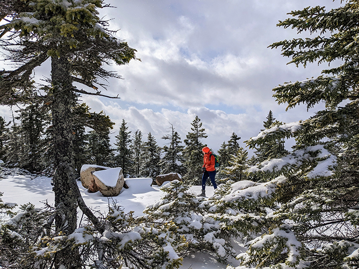
PHOTO: Snow has returned to the mountains. Bria on the south knob of Mount Paugus, elevation 3,100, in the Sandwich Range Wilderness. This peak is is on the popular 52 with a View hiking list. According to the AMC White Mountain Guide “Mount Paugus was named in 1875 by the poet Lucy Larcom for the Pequawket chief who led the Abenaki forces at the battle of Lovewell’s Pond in 1725.”

by Amy Patenaude
Outdoor/Ski Writer
Winter made its first big appearance last week. It snowed all over the State and especially at higher elevations. Snow didn’t deter us from going hiking and I really enjoy accompanying Bria as she works gathering her redlines.
Redlining around here means hiking every trail in the AMC White Mountain Guide. There are over 1,400 miles of trails described in the Guide. After completing a trail it is fun to take a red Sharpie to mark what you have hiked. I put the cap on my red pen 7 years ago and Bria has completed over 60%. She jokes with me that I am going to finish a second round.

Mount Paugus is located in the designated Sandwich Range Wilderness, west of Mount Chocorua. The Bolles Trail runs north-south between the Kancamagus Highway and Paugus Road between the two mountains. Bria has the three trails to Chocorua from the Bolles Trail but had not made a dent on Paugus yet.
We started at the south end of the Bolles Trail from the gate on Paugus Road. There were already a couple cars parked there. There was a good inch of crunchy snow on the ground. We both wore boots, trail running shoes won’t cut it now.

Up the Bolles Trail we went and then we turned left onto the Bee-Line Cutoff. We rock hopped across Paugus Brook and continued hiking half a mile until we reached the intersection of the Bee Line Trail. Then we turned right and hiked steeply down to Paugus Brook. The crossing here was not easy and we had to step on rocks that were under water an inch or two. I looked up and yelled out a greeting to two gals that were running down the Bolles Trail! We were surprised to see anyone else out here on a cold Thursday morning.
Bria needed this section of the Bolles Trail because when she came down Chocorua she went back to the Kanc. We tidied up this loose end by hiking back down to where we started up the Bee-Line Cutoff and then we hiked this half mile again.
Redlining requires a lot of repeating to get all the trails.
This time we went left to follow the other end of the Bee-Line Trail up to meet the Old Paugus Trail. As we climbed the crusty snow got deeper. We were pleasantly surprised that this surface was grippy and not slippery as the trails were covered with deep leaves last week.
A few times a snow shower passed by and we had some obstructed views of Chocorua through the leafless hardwood forest. The small brooks were flowing. We worked our way up the steep trail.
Just before we reached the Old Paugus Trail intersection we met two people coming down the
trial. They were making the same loop as we were but in the opposite direction but they skipped
going to the summit. They said they had to go to work and had run out of time.

Here the snow was a crusty three inches deep but on some of the steep rock scrambles bare
rock poked through and it was dry and lucky for us not icy. We used our hiking poles to keep our
balance and grabbed onto snow covered trees to haul ourselves up a steepest ledges. We were
rewarded after a difficult climb to the top of a ledge with a nice open view. We could see the
Ossipees, the Big Lake and further away we even spied the slopes of Gunstock.
Oooweee we’ll be skiing soon.
The sun would peek out now and then and we enjoyed its warmth and then a snow shower would come by again.
The trail ends at the top of the south knob of Mt. Paugus where it meets the Lawrence Trail.
From here we hiked down to the top of the big view ledge as described in the Guide. We could look down and see the fields of Ferncroft and west over to Mount Passaconaway through the light clouds. But we didn’t stay long on the snowy summit and chilly open ledge. It really felt and looked like winter.
We didn’t bushwhack to the true summit of Mount Paugus. We didn’t plan on it anyway and it was easy to skip because the trees were loaded with snow. Anyway Bria would have to return here again to redline the Lawrence Trail up from the other side of the mountain. Plus I had to get back home in time for my haircut (Bria you didn’t think I’d confess that, ha ha).
Hiking down went by quickly because we didn’t have to pay attention to route finding. We followed our tracks back to the trail intersection. Did I say these trails are in a designated wilderness area so there are no blazes to follow because for some insane reason a trail is okay but painted blazes aren’t in these areas.
We put on our down jackets when we cooled because our hearts weren’t pumping hard like they were when we were climbing. Back at the trail intersection we continued down the Old Paugus Trail and we were able to follow the other hiker’s tracks all the way to the Paugus Mills intersection. In some places the forest floor looked like the Pick Up Sticks game from the result of a long ago ice storm.

Near where the Old Paugus Trail meets the Bolles Trail, Bria spotted the remains of a foundation and there were lots of old bricks on the ground with the word Portland pressed into them. A barrel, some metal pieces and a sign reminding people not to take anything and to preserve the Paugus Mill’s history.
We successfully crossed the brook again. Was it my imagination that the water was higher? Or maybe some snow melted.
When we returned to my car a man was there looking at the trail signs. He asked us many questions about the trails that went to Chocorua. Bria answered since she had just done them this past summer.
We hiked over eight miles and more than 2,300 vertical feet in about four and a half hours. I made my haircut appointment with time to spare and Bria happily got to use her red Sharpie marker on her trail map.
Happy Fall and welcome Winter,
Have Fun.
Amy Patenaude is an avid skier/outdoor enthusiast from Henniker, N.H. Readers are welcome to send comments or suggestions to her at: amy@weirs.com.