
Mount Washington Drive & Hike
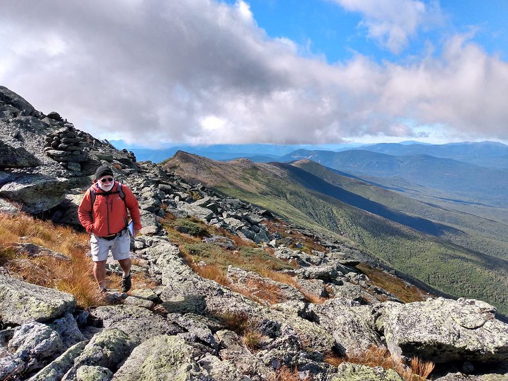
PHOTO: Carey Kish continued his research for his next guidebook on the Westside Trail. The Westside Trail bypasses Mount Washington’s summit between the Crawford Path and the Gulfside Trail. Much of the nearly mile of trail is paved like a sidewalk with carefully placed rocks through the Rockpile’s wild rubble. The grand vista has views down into the Ammonoosuc Ravine and down the spine of the Southern Presidential Mountains.

by Amy Patenaude
Outdoor/Ski Writer
My guidebook writer pal Carey Kish continued his research.
He needed to drive up the Mount Washington Auto Road to hike a couple of pieces of trail near the summit. I have made a summit circuit a few times and it is fun to hike on the Old Rockpile without having to hike all the way up from the bottom.
The Auto Road gates open at 8 am and we were among the first in line to head up the mountain. The toll for a car & driver is $35 and each adult passenger is $10. There is no advanced reservation necessary, it is first come first served. Plus the price includes the gift of their famous bumper sticker “This Car Climbed Mount Washington.”
As the toll house the attendant handed Carey a bumper sticker she told us that the summit was still in the clouds.
The 7.6 mile road is mostly paved but there are still plenty of narrow gravel sections up high and there are no guard rails anywhere. The average grade is 12%. If you have a fear of heights or don’t want to drive yourself consider taking their 2-hour guided tour in their stagecoach, a van with heavy-duty brakes driven by a skilled stagecoach driver.
I liked being a passenger while Carey drove. I kept my eye on the swirling clouds and enjoyed the view.
Since we were early it was an easy drive up since no one was driving back down yet.

Just before the summit there are a few small parking areas. He pulled into the space at the Huntington Ravine Trail. We both put on our jackets. The wind was strong and it was only 34 degrees. I put on my hat and gloves too.
Carey pulled out his GPS and his notebook and his plan was to hike down to the trail junction and back. I decided to hike more and meet him at the summit. A couple of trail runners came up over Huntington Ravine as we made our way down. At the top of the Ravine I turned on the Alpine Garden Trail, no flowers this time of year but the changing view across Pinkham Notch was fun to watch. I hadn’t felt a cold wind on my face in a long time.
I didn’t meet another person until I started my way up the Lion Head Trail. I climbed higher and deeper into the clouds. When I reached the Tuckerman Ravine Trail, the last half mile of steep scramble to the summit, it was nearly a total whiteout with scattered moments of quick cloud openings that gave me a brief window to see down into Tuckerman Ravine. This gave me faith the clouds would lift before our time on Washington was done.
I passed by a dozen hikers or so by the time I climbed past the trailhead sign and into the parking area of the Auto Road. The lots were filling up fast and the traffic control people stood out in their bright safety suits and helped hikers cross safely.

A Cog Railway car was unloading at the summit when I arrived. Due to social distancing rules the New Hampshire State Park’s Sherman Adams building on the summit is open to guests by reservation only. While the reservation is free of charge there is a $1 transaction fee. The way the wind was blowing everyone wished they had a reservation. I didn’t have one. Thankfully the Cog Railway has installed temporary restroom facilities adjacent to the train platform (four porta potties in a cargo box).
I found Carey and next up was a loop down the Crawford Path, across the Westside Trail and back up to the summit via the Gulfside Trail. As we went down the Crawford Path we began to drop below the clouds.
We met and chatted with a couple of Appalachian Trail thru-hikers making their way north to Katahdin.
When we turned onto the Westside Trail we enjoyed views down the spine of the Southern Presidential Range and to the Lakes of the Clouds AMC Hut. The trail is a pleasant walk like the Alpine Garden, another way to get around Mount Washington without going over the summit.
We nearly had the trail to ourselves; we only passed by one of the trailrunners we had met earlier in the morning.
The Westside trail crosses under the Cog Railway tracks before it terminates at the Gulfside Trail. I waved and blew kisses to the riders inside the purple train car and they did so too in return.

Hikers were scattered all up and down the Gulfside Trail making their way up or leaving the summit of Mount Washington. The clouds had mostly lifted and we could see the summit building and the towers above us. The views over the Northern Presidential and down into the Great Gulf are outstanding and the reason the Gulfside Trail is a popular hiking route. The day had turned into a super day to visit Mount Washington.
The ride back down the Auto Road was slower and everyone had to drive with more care to share the road since it was late morning and a line of traffic had formed in both directions. Carey pulled over a couple times to cool his brakes and to enjoy the mountain views from up high for a little longer.

My total hike was just over 4 miles and I never went below elevation 5000 feet. I confess it was great fun to have a big mountain experience without the big effort.
No matter how you get to the summit, by car, train or by your own feet be sure to be prepared for Mount Washington’s notorious changing winds and weather.
Have Fun.
Amy Patenaude is an avid skier/outdoor enthusiast from Henniker, N.H. Readers are welcome to send comments or suggestions to her at: amy@weirs.com.