
Muchyedo Banks Paddle
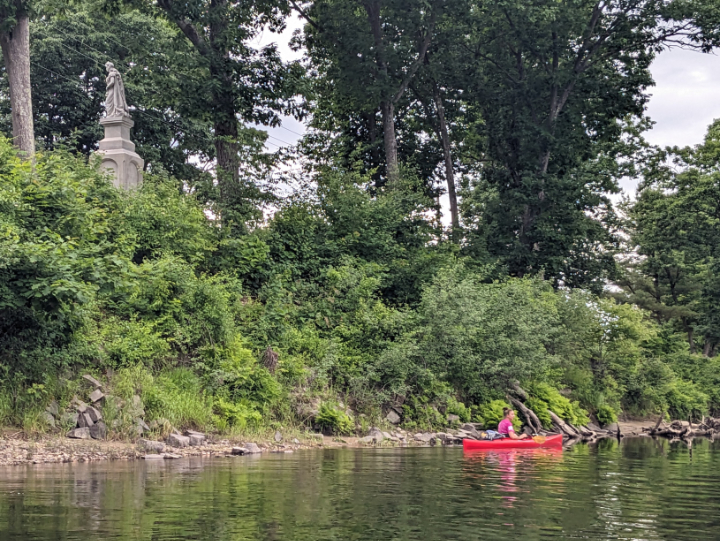
PHOTO: Becca paddles past the statue of Hannah Duston where the Contoocook meets the Merrimack Rivers. The memorial was erected in 1874 and is the first publically-funded statue in New Hampshire and the first statue in the United States to honor an American women. The Merrimack Paddle Challenge is a collection of five destinations in the Merrimack River watershed created and presented by: the Society for the Protection of New Hampshire Forests (for more information visit ForestSociety.org), Five Rivers Conservation Trust, Lowell Parks & Conservation Trust and the Merrimack River Watershed Council. The Muchyedo Banks Paddle part of the Merrimack Paddle Challenge.

by Amy Patenaude
Outdoor/Ski Writer
The Muchyedo Banks Paddle is one of the five paddling adventures that make up the Merrimack Paddle Challenge. This route starts at the end of the Contoocook River in Penacook and then heads upstream on the Merrimack River. The Merrimack River is the boundary of Boscawen and Canterbury.
While I was hunting for information to learn if there was any way around the dams on the Contoocook River just before it meets the Merrimack River I found the Merrimack Paddle Challenge. Right there on the Society for the Protection of New Hampshire Forests’ website I found the maps I needed and an invitation for another adventure Becca and I could work on this summer.
Becca and I made up our own challenge last summer to section-paddle as much of the Contoocook River as we could. We portaged around dams and technical white water sections and we paddled from Bennington to Penacook–just shy of meeting the Merrimack River. I noticed right away we had already completed one of the Merrimack Watershed routes included in the Challenge.

We could check off the Contoocook River Paddle on the list! We had already paddled from Contoocook to the last boat ramp in Penacook before the dams. It would have been nice to have had their nice map.
After work we Becca and I met at the Rivco Boat Launch at the end of Merrimack Street in Penacook. We were in our boats at 4:30 pm and of course we tried paddling up the Contoocook but we didn’t get very far. The water was too fast and too shallow. We weren’t able to get near the dam. So we began the Muchyedo Banks Paddle.
Leaving the Contoocook River we passed underneath an old railroad bridge. There was a man fishing on the shore beneath it and he wasn’t catching anything. The water didn’t feel like it was moving fast so we easily turned left and paddled upstream on the Merrimack River.
After a few minutes of paddling we could see on top of the island’s bank above us, the memorial statue of Hannah Duston. Next we paddled under the Route 4 bridge, there was some nonsense graffiti on the concrete abutments.
We could tell we were paddling upstream, if we stopped paddling our kayaks would start floating back downstream. We hoped we could paddle two miles an hour so we could make the turn around at 4 miles in two hours. The way the river meanders and forms oxbows the depth of the river and speed of the water varies a lot.
The Town of Canterbury manages conservation lands that make up a nice sandy beach at Riverland. There were no people on the beach but lots of footprints had been left behind in the sand. The water looked clear and the sandbar looked like a fun place.
Soon we could see the sandy cliffs of Muchyedo Banks. There were hundreds of Bank Swallows and the birds fled their “holes in the wall” nests as we paddled past. They flew in circles above the river as they waited for us to go away. This was exciting to watch the birds fly out and in their holes in the bank. Their holes aren’t round, we noticed but wider at the top to allow their wings to enter more easily.
We could hear Interstate 93’s traffic roaring, too many motorcycles are too loud. The Muchyedo Banks are near the highway but as we paddled more the oxbow led us away from the highway again.
There is almost no development along the River here. Much of the land is held in conservation and agricultural easements.

We saw a Great Blue Heron, the big bird would fly away from us and then stop and then as we neared it took off again.
We also enjoyed seeing a few small Sandpipers. They were so cute running up and down the sandbar.
There were no other boats on the river except one solo kayaker coming downstream who said he had come from Boscawen.
We were running out of time, two hours had come and gone fifteen minutes ago. We were out of snacks too. The last instruction on the suggested route is “make sure you turn around with enough energy to paddle back to the launch point at the mouth of the Contoocook.” Maybe they should have added, “ Don’t forget what time it gets dark.”

At 4 miles, we hit our solid turn around time and we reversed our direction at two piles of rocks in the river. We had no way of knowing if Mother Nature had piled these up or were they made by man? We met the solo kayaker paddling upstream and we wondered how he’d get back by dark?
Downstream paddling was almost twice as fast and a lot of fun. We were happy to get back earlier than we had planned.
Since it was only 7:30 pm and we still had some daylight to burn, we tried to paddle around the Hannah Duston Island. But there wasn’t enough water to make it all the way around–it was grown in and grassy. It appears water only flows from the Contoocook here in very high water.
This was a fun adventure that I don’t think I would have thought of doing. Now Becca thinks we should continue North on the Merrimack River all the way to its beginning where the Pemigewasset and the Winnipesaukee rivers meet in Franklin.
Of course we still have three more Merrimack Paddle Challenges to complete.
Have Fun!


