On The Appalachian Trail In Maine: 100 Mile Wilderness & Katahdin – Part I
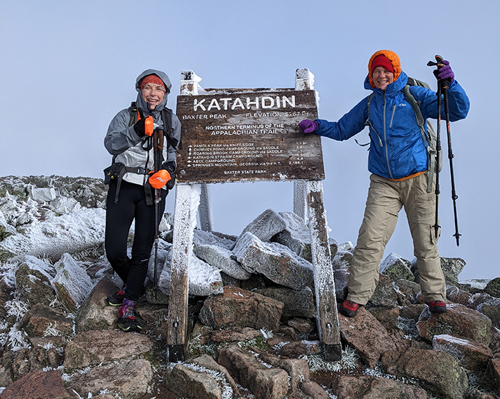
PHOTO: Julie Weisman (L) of Franconia, NH and Amy Patenaude on the summit of Mt. Katahdin on the morning of September 16th. It was their 9th day of backpacking across the 100 Mile Wilderness and Baxter State Park. Baxter Peak on Katahdin, elevation 5,267 feet, is the highest point in Maine and the Northern Terminus of the Appalachian Trail. Rime ice welcomed them above treeline along with 20-30 mph winds. This week we present the first part of their two part adventure.

by Amy Patenaude
Outdoor/Ski Writer
A year ago, last September Julie and I backpacked from Stratton To Caratunk and then a few weeks later, thanks to unseasonably warm weather, we went back to Maine and completed the section from Caratunk to Monson. Then all that was left for me to complete the Maine Appalachian Trail (AT) was the 100 Mile Wilderness and Mount Katahdin.
Julie had been home just a few weeks since backpacking the John Muir Trail with her daughter. She assured me she was excited to go. Certainly she was in great shape after covering a couple hundred miles in the Sierras.
We drove to Monson on the Wednesday after Labor Day.
A mile up the road from downtown Monson and the popular hiker hostel Shaws is 100 Mile Wilderness Adventures and Outfitters where we had booked a cabin, a shuttle and a food drop. The owner, Phil Pepin, dreamed and built a wonderful place for outdoor enthusiasts who prefer a more traditional Maine experience. It is a quiet place where you can hear the Loons and gaze at the bright stars and maybe play Scrabble or sit by a campfire. There’s no wifi.
Pepin, a Registered Maine Guide, has thru hiked the AT and knows the 100 Mile Wilderness well. He suggested campsites and marked our maps and showed us the location of his bear box for the food drop. He made us coffee in the morning too. When he dropped us off he told us to contact him if we needed anything.
Day 1, Thursday Morning,
The Distance To Katahdin Is 114.5 Miles.
Just after 7am we headed up the AT, carrying our heavy backpacks with five days of food and a couple of liters of water. We walked over slate ledges, slippery when wet and past ponds. Three times we had to remove our trail shoes and put on our Crocs to wade across the streams. The water was cold and felt good. We passed by three Maine Men. That’s what I called them since they were from Maine and they were also section hiking like us.

After the challenging crossing of Long Pond Stream, sometime before 5pm, we found a nice spot just off the trail to set up our tents. While we were eating our supper we watched about a dozen thru-hikers cross the stream and then they continued up the trail. 14.3 Miles hiked.

Day 2, Friday morning we were up early, we were on the trail between 6 and 6:30 each morning. Oatmeal with a few raisins and prunes and black coffee is what I ate every morning for breakfast. The Maine Men passed us as we started up Barren Mountain. We took a side trail to the top of Barren Slide and we hiked the mountain’s ledges. On the summit is an old lookout tower with no cabin. I climbed up the ladder up the frame and took in the big vista.

We chugged up the Fourth Mountain on a new relocation of the trail that now passes by a small airplane crash site. Here we met a slack packer, a day hiker. He told us that he was told no one died in the crash and he was paying for drop-offs and picks up every day so he didn’t have to backpack. We thought that sounded fun but expensive. The logging roads into the 100 Mile Wilderness are long slow rides.
Third Mountain wouldn’t quit, it felt like it had three summits. Then Columbus Mountain felt quick and it felt too early to stop at the Lean-to so we decided to continue and camp at East Chairback Pond. The pond didn’t look far away but it was a long walk from Chairback Mountain. We passed by a trio of Southbound Thru Hikers. We were most thankful for the new stone steps built to descend off the mountain.
The Maine Men tents were already set up by the water’s edge. We set up our tents further up the hill from the pond. We went for a good swim, ate supper and went to sleep before it was dark.
Looking back on this second day I realize this was the most strenuous day of the 100 Mile Wilderness. The constantly varying terrain had lots of interesting sights– even a bog with Pitcher Plants and a crashed airplane, made the Barren-Chairback Range a rugged rewarding day. 14.4 Miles hiked.

Day 3, Saturday, the day started off with the steep quarter-mile uphill climb from the pond up to the AT and then a long downhill to the West Branch of the Pleasant River. The River was wide and shallow and again we had to wade. Then we ground our way up the trail following Gulf Hagas Brook and then up and over the Brook’s namesake mountain. On top of the wooded summit the Maine Men were taking a break. We took a snack too. And the slack packer man hurried past us this time headed southbound!
We were surprised how few Northbound (Nobos) AT thru-hikers we saw while hiking. We usually only saw them hiking by our campsites late in the afternoon. I guess they like to sleep late and go to bed late too.
We enjoyed the steep climbs with wonderful stone step staircases that reminded us of hiking in our beloved White Mountains. We were happy to find the summit signs on the wooded peaks of West Peak and Hay Mountain. The final push up to White Cap Mountain to its bare summit energized us for our first big view all the way to Mount Katahdin. Oh, it looked so far away. We chatted for a quick minute with two older Nobos and then we had the summit to ourselves.
It was warm in the sun and there was a breeze. It looked like we were having a small yard sale with our clothing laid out over the rocks to dry. Here painted on a rock was a big white “K” with an arrow pointing right at Mount Katahdin.


We made it down to the Logan Brook Lean-to. The tent sites looked pretty bad but a short walk down the trail we found a flat rocky tentsite that looked good enough. The brook had excellent drinking water. Julie told me while I was getting water that the Maine Men had passed by and decided to keep on going. Again 14.4 miles hiked.
For suppers we split dehydrated store-bought hiking meals for two. Some were better than others but they were never really enough for two people with hiker hunger. Thank Goodness both of us packed plenty of snacks of cheese and meat sticks. I shared my chocolate covered pretzels with Julie since she managed not to bring along any chocolate.
During the night Julie woke me up and told me I had to look at the Moon. I got out of my tent and it was full and shining right down the middle of the trail. I later learned it was 4:30am.
Day 4, Sunday was the beginning of 2 for 1 Maine Miles. We all know that Maine miles are longer than most miles, but when the trail is nice and soft and wide and easy we can earn 2 Maine Miles for the effort of one. Doesn’t happen often but when it does it is fun. We felt like we were flying. Maybe the faster I hiked the less my shirt smelled?
Clothing: two pairs each of socks and underwear, shorts, shirt, long sleeve shirt, pants, sleeping shirt & long underwear, down jacket, hat, gloves, rain jackets & pants. Julie carried similar clothing too. This is all we had to wear for the 9 days for whatever the weather brings.
After the Chairbacks and White Cap, Little Boardman Mountain felt as little as its name. And from its summit it was all downhill 2 for 1’s for the next eight miles to Jo-Mary Road and our re-supply.
The sign read Sand Beach and it was not even 11 o’clock but we decided we should go swimming since we didn’t get a chance to do it the day before. Crawford Pond was heavenly. We swam and we swam. We rinsed out our shirts and ate lunch on the shore in the sun. This place was a perfect 10 on the wonderful wilderness scale.
We took the short spur down to Cooper Brook Falls Lean-to. It sits just above a big pool at the bottom of a loud beautiful cascade. Here we once again found the Maine Men and a few others hanging out. It was only maybe 1pm so we decided to keep on hiking.

We smelled the barbeque before we saw it. We dropped our packs on a good campsite on the brook just before crossing the road. Yikes! The fabled Trail Magic by Chili P. was set up right on the trail at Jo-Mary Road. He welcomed us and offered us anything he had and he was serving cold drinks and hot food. 15.4 miles hiked.
Julie and I ate grilled local corn and Kielbasa. I had a cold Coors Light and Julie drank a cold orange soda. She never drinks soda!
Then I walked up the road and into the woods to find the bear box that held our food. I found it and I unlocked it but our stuff wasn’t in the box. We were half a day earlier than we had planned but it was supposed to be here already.
Julie carried a Garmin-Inreach, she used it each night to text via satellite our husbands so they would know where we were and that we were happy. Julie used it to text Phil and he responded right away that he would be there at 6pm and he was sorry, he was on a rescue. No worries, we carried our supper with us anyway and we could enjoy nearly three hours of trail magic until then.
This was the most people we had seen on the trail. Hikers came from all directions to find Chili P’s Trail Magic. The Maine Men showed up, followed by all those Nobos that started late in the morning. They had heard from the Sobos that there was Magic ahead and they came literally running. The food was awesome and extremely satisfying but sitting in a chair felt the best.
Everyone agreed sitting on a chair especially with a belly full of food was magic.
Phil arrived at six and handed over our resupply bag and apologized. He told us we had made very good time on the trail, we’d hiked 58.5 miles and lots of mountains. There was nothing to be sorry about. Everything worked out. He told us how one of his guests had slipped on the slate ledges and needed help getting off the trail. Then he drove him to the hospital where the poor fellow got 18 stitches on his knee.
Before hitting the sack we waded in the cascading waters of the brook to clean up. Then we organized the additional food in our backpacks. We gave away some oatmeal, some cheese and a dehydrated meal we didn’t eat to a couple Nobos that were running low on food.
Chili P. would reopen in the morning sometime around 7 am but we’d be long gone down the trail by then.
Our tent site reservation at Katahdin Springs Campground was for Thursday Night the 15th and we hoped to summit Katahdin the next morning.
Baxter State Park has strict rules that even Thru-Hikers have to follow. There is no dispersed camping allowed in Baxter State Park. Everyone must pay to sleep in the park and there are only 12 spots available at the Birches, the campsite reserved just for AT hikers. The best bet is getting a campground reservation. Otherwise you have to wait outside the park until there is a space available.
Three more sleeps and we would be arriving at Katahdin Stream Campground.
Happy Fall,
Have fun.
To Be Continued…
Read Part II Coming Up In Two Weeks!
Amy Patenaude is an avid skier/outdoor enthusiast from Henniker, N.H. Readers are welcome to send comments or suggestions to her at: amy@weirs.com.