On The Appalachian Trail In Maine Stratton To Caratunk
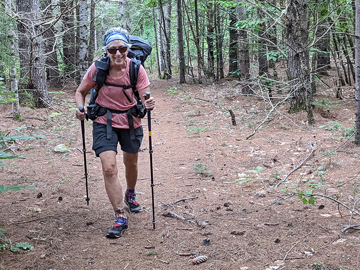
PHOTO: A sunny morning above Horns Pond with North and South Horn peaks above. Julie’s pack weighed nearly 30 pounds the first day since food and water weigh a lot. The Appalachian Trail goes over the summits of South Horn, Mount Bigelow-West Peak, Mount Bigelow-Avery Peak. Both Bigelow peaks are on the New England 67 list of 4,000’ mountains. South Horn just under 4000’ makes the New England Hundred Highest list.

by Amy Patenaude
Outdoor/Ski Writer
The Appalachian Trail (AT) crosses ME27 in Stratton, Maine, just a few miles west of the Sugarloaf Ski Resort’s access road. The sky was mostly blue but the forecast called for changeable weather with thunderstorms headed our way by early evening.
It was Sunday morning and we were hiking Mount Bigelow. Our plan was flexible, we weren’t sure how far we would hike north each day, but we hoped to make it to US201 in Caratunk by early Wednesday. The distance on the AT between these two points is 37 miles and over 8,000 vertical feet of climbing. We’d just follow the AT’s white blazes and see what we would find.
ME27 to Safford Notch Campsite, 10 miles.

Mount Bigelow is a long mountain ridge with several peaks and is as rugged a hike as you can find in the Northeast. We worked hard climbing up to the ridge. We rested on Horns Pond’s shore and the sun sparkled on its waters.
The steep climb up to South Horn was a grind. I dropped my pack and did a quick out and back to the North Horn while Julie pressed on. From there the top of the South Horn looked impressive and the highest summit of Bigelow, the West Peak elevation 4,145’, looked far away. Julie was waiting for me and enjoying the big mountain vista that included Sugarloaf and the Crockers. It was very windy and puffy white clouds began to fill the sky.
On West Peak the wind swirled the clouds and engulfed us. We had a fleeting view of the mountains and Flagstaff Lake below, but that was it for the rest of the day. It was then a steep descent to the col and we filtered water out of a box spring on the trail just past the campsite.

Up and over Bigelow’s Avery Peak and then the long descent to Safford Notch, just a few more miles and 2000 feet to descend to reach the campsite. We met a few people hiking southbound trying to reach the col. We were glad we were headed down because the wet weather was moving in.
Down, down, down, to the Notch below. Just before the campsite we began passing by huge boulders, seriously huge boulders, some covered with moss and in the dim light the enormous boulders looked spooky. The spur to the campsite led us through a cave between the boulders. A few people had already set up camp. We found a flat spot, set up our tents and then went to the nearby brook to filter water. We split my chicken salad sandwich and Julie shared her mac & cheese with summer sausage with me for supper.
Just as night came, so did the rain and the arrival of a dozen AT thru-hikers. They were noisy, built a giant fire and set up their tents in places around that fire ring where it didn’t look possible to set up a tent. When it began to rain hard it became quiet and everyone was off to bed by 7:30 pm.
After more than 10 miles of hiking and climbing we slept well and looked forward to the morning when we would begin another long walk.


Safford Notch Campsite to West Carry Pond Lean-to campsite, 12 miles.
During the night the rain stopped. We said goodbye to the boulders and headed up and over Little Bigelow Mountain. It was a lovely day and the forest and the mountain vistas filled our eyes. The long descent on wet slippery ledge and rocks was challenging and we were glad we made it off of Avery before the rain. On an open sunny ledge we took a long break and unpacked our tents to dry out while we ate a second breakfast. Gone with the Wind, a retired couple from Georgia we had met at the campsite, caught up to us and our break overlapped with theirs.
We met a local older couple along the shore of Flagstaff Lake who are the volunteer trail maintainers of that section and they told us wonderful stories about the area. Julie soaked her feet in the Lake and I went for a dip. We enjoyed our long walk in the forest. Big Pines and delicate looking young Cedar trees lined the trail.
At West Carry Pond Lean-to we saw Loons as we filtered the pond water to make our supper. We were the first at the site and when we heard thunder we quickly set up our tents and finished the task just in time to stow our gear inside as the sky dumped buckets of rain. We ran to the lean-to with our food and prepared supper high and dry inside. Gone with the Wind arrived first and one began to prepare their supper while the other set up their tent. An hour later the rest of the gang from the previous night arrived soaking wet. After a couple of hours the rain let up and they built a huge fire and stood around it trying to dry off. 8pm is hiker-midnight.

West Carry Pond Lean-to to Harrison’s Pierce Pond Camps, 11 miles.
The Loons sang to us all night long and it was a lovely morning. Gone with the Wind and most of the others left before the sunrise to hike the flatish 15 miles to reach the Kennebec River crossing before the canoe-ferry stopped running at 2pm.
We continued our long walk and we walked in the footsteps of Col. Benedict Arnold’s army on their way to attack Quebec; the AT follows their portage trail between Middle and West Carry Ponds.
The long walk went by quickly with good footing and no hills. We met a solo gal hiking towards us and she was floating on air. “I met the cutest guy and I ate the best pancakes at Harrison’s,” she sang as we crossed paths. At Pierce Pond Lean-to, posted on its wall, was information about the happy pancakes. We ate our lunch on the shore of Pierce Pond and we headed to Harrison’s Maine Hunting Camp just a third of a mile off the AT and decided to stay.
Our host, Tim, showed us to a rustic log cabin right on the bank of the Pierce Pond Stream. Truly a hiker’s heaven. We spent the rest of the afternoon soaking and dipping in the stream’s cool water.
We missed the sunset over the pond and the song of the Loons but we had our sleeping bags spread out on good mattresses and the sound of the stream lulled us to sleep.

Harrison’s Pierce Pond Camps to the Kennebec River, Caratunk, 4 miles.
The authentic Maine Hunting camp has a history beginning in the 1930’s and we learned that Tim has owned and run the camp the last 36 years. Living in the wilderness is a labor of love and the joy that he is able to share with hikers and other sportsmen is a gift. Julie and I talked about returning to kayak and bird watch.
Breakfast served at 7am sharp is limited to 9 hikers that made a reservation in person the previous evening. $12 buys 12 patriotic pancakes, raspberry, banana and blueberry and a side of sausage and eggs. Deer mounts and trophy fish are hung on the dining room walls and there is a fine view of the stream out of the window. Breakfast ended at 7:30 and we were back on the trail.
Julie told me that the crossing of the Kennebec is the lowest elevation of the AT in the State of Maine. It felt like we had been walking downhill for two days. Now we followed the stream while admiring its cascades and waterfalls all the way to the big River.

The canoe ferries the first hikers at 9am and we arrived in time to see the first hikers reach the other side. We sat on a log with the 4 hikers that blew past us on the trail earlier. The Maine Guide takes two hikers across at a time about every 15 to 20 minutes. The hiker in the bow gets to help paddle. Just before it was our turn two hikers arrived. We made them crazy happy by letting them go ahead of us since our hiking was just about over.
The wind blew and there were a few white caps. I wished we could have paddled upstream to enjoy the river longer. It was a short walk to reach the paved road and small parking area where my car was waiting.
We both would have liked to keep on going to Monson. Next time.
Have Fun.
Amy Patenaude is an avid skier/outdoor enthusiast from Henniker, N.H. Readers are welcome to send comments or suggestions to her at: amy@weirs.com.