
Shelburne Trails Tramping
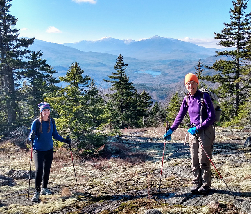
PHOTO: Bria Clark and yours truly on one of Mount Ignall’s fine view ledges. We enjoyed the view over the Androscoggin River all the way to the snow capped peaks of the Northern Presidential Range.

by Amy Patenaude
Outdoor/Ski Writer
Mother Nature continues to usher in Winter to the mountains, but so far lower elevations have remained relatively ice and snow free. We took advantage of the Shelburne Trails to enjoy some nice fall hiking.
The AMC White Mountain Guidebook refers to Mount Ingalls and Mount Crag as part of the Southern Minor Peaks in the Mahoosuc Range Area Chapter. The trails were originally opened in the 1950’s and due to logging the trails were abandoned and the Shelburne Trails Club reopened these trails in 2010.
The Shelburne Trail Club has produced a wonderful detailed map and it is available at your favorite bookstore or directly from the Club. Thanks to their efforts the trails are well marked and are in excellent condition. These trails are lightly used and are well worth visiting for hiking and snowshoeing.
From North Road Charlie and I drove up the gravel Mill Brook Road about half a mile to the Scudder Trailhead. Bria and Jeremy arrived right behind us.

It has been a few years since I last hiked here when I participated in a volunteer work day on the Scudder Trail. I noted the new trail signs.
We grabbed our packs and headed up the well blazed Scudder Trail. The first mile or so the trail is a wide old skidder road. As the trail narrowed it traveled in a buffer of trees between not too long ago logging operations.
Above the intersection with the Cabot Connector Trail we continued up more steeply in a wonderful hardwood forest. Deep dry leaves can be slippery but luckily the wind had swept much of the trail clear.

Up the ridge we hiked and the trail crossed several open ledgy areas. We took a snack break at the large west facing ledge. We could see the white capped peaks of the Presidential Range including Mount Washington above the sparkling waters of the Androscoggin River below.
There are a few more outlooks, some better than others but this time of year, when the leaves are off the trees, there is plenty to see afar.
Just before arriving at the top we crossed another fine view ledge. The summit of Mount Ingalls is tree covered but there is a summit sign proclaiming its elevation of 2,242 feet.
From the summit we continued a tenth of a mile down the path to Ray’s Pond. The small mountain tran was covered with a thin layer of ice.
The distance from Ray’s Pond from our car was under 3 miles. We retraced our footsteps back, once again lingering a few more moments at every outlook.

There are many loop options in this area, but we stuck to our out and back plan until we were nearly to our cars. Since the day was so lovely we decided to turn up the Yellow Trail to Mount Crag. Of the four of us only Bria had not been to the top of this delightful bump, just an elevation 1,412 feet. Mount Crag has one of the biggest bang for your buck hiking efforts around. Its summit ledge is mighty fine.
After crossing Mill Brook Road we carefully rock hopped across the Brook and in a few feet we saw the cable car sign. On this side of the brook on the Yellow Trail there is a short spur to a cable car that crosses the Austin Brook to Mill Brook Road just a 100 yards uphill of the Yellow Trail crossing. Of course we had to check it out. Not only was the cable car fun, it is rather handy for crossing the brook.

Right before the trail begins to climb steeply there are some impressive large glacial boulders on the south side of the trail. We followed a herd path made by other curious hikers that had tread before us and we circled the big rocks. There was a boulder cave but none of us crawled through it.
The sun was bright and it was warmer here than it had been on Mt. Ingalls’ ledges earlier. A couple with a baby were preparing to leave when we arrived, the first people we had met on the trails all day. We sat in the sun and admired the mountain views for a long time. A pair of Corgi dogs arrived and in a few minutes their owner did too. The pups were friendly and we learned they lived nearby. I noticed she was wearing a STC hat.
Bria and I continued down the other side to the Gates Brook Trail while Charlie and Jeremy went back to our cars. We passed by a couple other hikers doing the short hike to the summit, from Austin Brook Trailhead to the summit of Mt. Crag is 7/10ths of a mile one way. We beat the boys back down so we walked along North Road past the Austin Brook Trailhead where they scooped us up and took us home.
Conditions change fast in the mountains and snow is in the forecast. I hope everyone is looking forward to winter snowsport fun, I sure am.
Have Fun.
Amy Patenaude is an avid skier/outdoor enthusiast from Henniker, N.H. Readers are welcome to send comments or suggestions to her at: amy@weirs.com.