
Snowshoe To Mount Shaw
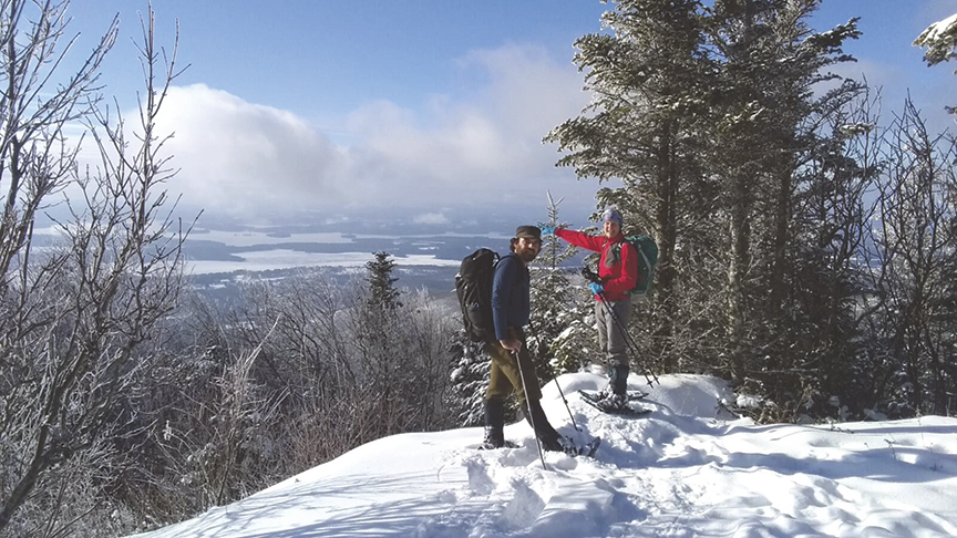
PHOTO: Outdoor Columnist Amy Patenaude with Zachary Porter on the snow covered open ledges of Big Ball Mountain overlooking Lake Winnipesaukee. BECCA MUNROE PHOTO

by Amy Patenaude
Outdoor/Ski Writer
Mount Shaw, elevation 2,990 feet, is the highest peak in the Ossipee Range and its summit and much of the south slopes of the mountains are part of the of the Castle in the Clouds Conservation Area. At over 5,000 acres, this is the largest property conserved and stewarded by the Lakes Region Conservation Trust.
Mount Shaw is a popular mountain. Mount Shaw is included on the popular hiking list “52 with a View.” The mountain is ranked #178/200 of the NH highest and with 2,330 vertical feet of prominence it is among the top half of the New England Fifty Finest.
Yet the most popular and direct route to the mountain is the unmaintained Mount Shaw Trail beginning on the north side of Route 171 just east of the intersection of Sodom Road in Tuftonboro.
Older AMC White Mountain and Southern NH trail guide books include a trail description. It’s also easy to find on-line maps of this area. As always, great care should be taken to know where you’re going and, more importantly, be sure to know how to get back to where you started.

At the trailhead parking area there is a sign that reads “Family Owned Since 1918 Please Treat Respectfully, No vehicles, carry in, carry out, Use at your own Risk.”
The small parking area wasn’t plowed but the snow was well packed down by cars. Becca, Zachary and I met at 8:30 am and we weren’t the first car in the lot. We put on our snowshoes and grabbed our packs and headed up the trail.
The path was tracked out and we probably didn’t need the snowshoes but they would be very nice to have soon. We planned to make a loop up over Big Ball and Black Snout on our way up and to do a little bushwhacking off-trail.

The Mount Shaw Trail continues straight up along the bank of Fields Brook and we turned to the right up another road where the snow was not tracked out and the path was marked by a few green blazes with a red dot in the middle. As we made our way up the mountain the snow increased from 4 inches to well over 8 inches.
The bare summit of Big Ball, sometimes called Tate Mountain, gave us big views south over Lake Winnipesaukee and we could see Gunstock Mountain’s ski trails. It was a hazy cloudy day but bits of sunshine were shining through along the way.
Between Big Ball and Black Snout we followed fresh moose tracks!


After reaching Black Snout we were now on the Castle of the Clouds carriage paths that are well blazed and signed. Since we had our snowshoes and a compass we pretty much made a beeline for the top of Mt. Shaw and cut the corners of the carriage paths.
Mount Shaw has a wonderful open view but the clouds were rather low so we couldn’t see the big prizes of the White Mountains. But we had nice views of the rest of the Ossipee Mountains and of the snow covered Ossipee Lake.
We enjoyed our sandwiches and the view at the outlook. Soon three women joined us on the summit, they all wore micro spikes on their boots.
On the way back down we followed our tracks and when we popped out onto the Black Snout carriage road we landed right in front of three people who had just come from Mount Shaw. We must have missed them while we were bushwhacking. They started all the way from the Castle In the Clouds, taking the longer High Ridge Route.
It was easy to find the Mount Shaw Trail since the route was well packed out by many hikers and snowshoers. We kept our snowshoes on for the benefit of having solid footing on the slippery packed snow.
We passed by several small groups of people who were headed up the trail. Most of the people wore micro spikes instead of snowshoes..
Zachary kept his snowshoes on all the way back to the car. Becca and I took them off at the brook crossing and kept them off. The parking area was now full with about a dozen cars.
Our route was about 7 miles. It was wonderful to be out in the snow on a mild winter day.
Have fun.
Amy Patenaude is an avid skier/outdoor enthusiast from Henniker, N.H. Readers are welcome to send comments or suggestions to her at: amy@weirs.com.


