
The Cohos Trail – 4th Connecticut Lake To Young’s Store
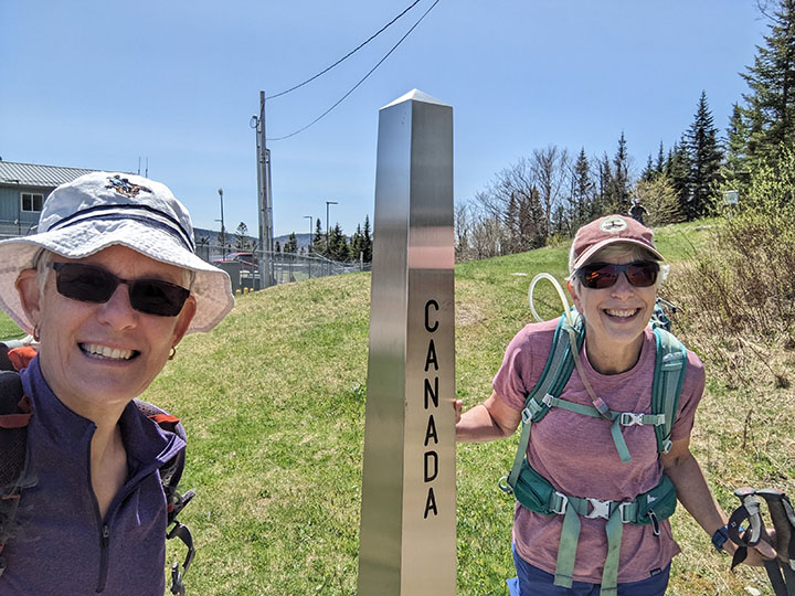
PHOTO: Yours truly and Julie at the start of our southbound Cohos Trail section hike. The northern terminus of The Cohos Trail is in Pittsburgh, NH on the Canadian border. The 170 mile Cohos Trail crosses the entire length of Coos County from the White Mountain National Forest to the Connecticut Lakes Region. Many trails along the Cohos Trail make wonderful day hikes. The hike along the border swath to the headwaters of the Connecticut River, 4th Connecticut Lake is a short two mile hike round trip. Falls in the River Trail along the Connecticut River just below 2nd CT Lake is a favorite for its loud and lovely cascading waters. These two hikes are worth the long drive to the Great North Woods.

by Amy Patenaude
Outdoor/Ski Writer
The Cohos Trail runs the length of Coos County from the Canadian Border to its most southern reaching point at the bottom of Crawford Notch in Hart’s Location. The trail is 170 miles long. Some people backpack and thru-hike the entire trail but a lot of people section hike the trail too.
Julie and I decided to section hike The Cohos Trail going south bound (Sobo) starting from the Canadian Border and have the most fun doing it. To slack pack we had to each drive our own car so we could hike a section point to point. This way we could travel light by spotting a car at our day’s end. The most northern part of the trail lends itself well for slack packing because we’d always be near Route 3 and the trail is made up of many trails that are popular day hikes.

Julie left her car where the trail crosses at West Inlet Road and then she jumped into my car and we drove to the border. There is a day parking area for hikers and there is no need to check in with customs. We grabbed our packs and walked to the border and the trailhead. We headed down Sophie’s Lane and began hiking Sobo to Julie’s car.
Friends warned us it would be buggy and muddy but our headnets stayed in our packs and our feet stayed dry thanks to the dry weather. We followed the snowmobile trail/forest road south and enjoyed the rolling terrain and walking along the west bank of the 3rd Connecticut Lake.
The wild flowers weren’t open yet; spring was still early here two hours north of Franconia. We kept our eyes open for Moose but we didn’t see any.

Just south of Deer Mt. Campground we left the snowmobile trail and headed down Upper Blackcat, a nice path through the forest. We followed the yellow blazes that helped us stay on the trail. Even though we weren’t far from Rte 3 it was so quiet.
With now a good 7 miles behind us we were on our way and needed to go back to get my car and to complete the official northern terminus of the trail. The 4th Connecticut Lake Trail is a two mile lollipop-loop that is a popular day hike. We hiked east along the border swath and made the shortish-steep (400 vf) climb up to the headwaters of the Connecticut River.
We went clockwise around the small boggy lake and before heading back down the swath we took a herd path down to the edge of the water to sit down and eat our lunches. We watched a duck swim around while I reminisced about the last time I was here when the weather was not as nice. This day there were no bugs and lots of warm sunshine, we counted our blessings.
Nearing the custom buildings the sound of the flags flapping in the wind was surprisingly loud. Before calling it a day we spotted the cars again to hike more. We continued down Middle and Lower Blackcat. We took the spur path down to the spring for some nice cold water. The tree’s leaves were not out and we enjoyed the open woods. We noticed a lot of fresh sawdust made by volunteers using handsaws to remove trees that had once blocked the trail. We were happy to have a well marked and clear pathway as we hiked SoBo.
We crossed Rte 3 and began walking down R&J Chaput Trail and past Lainie’s Lair. We didn’t find anyone hiding in the cave but when I climbed up the ledge and around the big boulder there was a bench where one could sit and keep an eye on the trail.
We’d been hiking in the forest just west of 2nd Connecticut Lake and then we popped out at its dam. Below the dam The Falls in the River Trail begins and it is another popular trail for day hiking. The trail follows the Connecticut River and its beautiful cascading waters and to the gorge known as Falls in the River. We took our time and enjoyed the river, taking herd paths to be closer to the edge of the river. This was our last section of the day and we took the Moose Alley Spur back to the trailhead parking.
Lucky us we had a wonderful supper at the Buck Rub and we got a room in their lodge right behind the restaurant for the night. After hiking 15 miles we sure slept well.
The next morning we were waiting outside of Young’s Store to open at 7 am with a few others. They make the best breakfast sandwiches and coffee. We left a car at the Cohos Kiosk near the store and we drove back to where we left off.

We thought Moose Alley Trail would have moose and we hiked silently hoping at least one would show up but such luck.
The Bog Bridge Trail was fun, the boardwalk was long. We passed by materials ready to replace the rotten boards. I learned that the work would be performed on National Trails Day, June 3rd by volunteers.
We crossed Rte 3 again and headed up the Round Pond Brook Trail. We passed by the recently oiled Tillotson Hut, the volunteers take such good care of everything up here. This new shelter was once on display at the Museum of the White Mountains before it was reassembled on the trail.
We followed the brook then we hiked around the pond on the road past houses. Then we began our push over Covell and Prospect Mountains. I have visited these peaks before when I was checking off the 2k peaks on the New Hampshire Highest 500 list.
This day was a lot hotter than the previous day and we really felt the heat as we worked our way up and over the mountains. Again the trail was pretty and well marked and maintained.
From the summits we enjoyed big views across 1st Connecticut Lake to Magalloway Mountain and beyond. Every once in a while a black fly would bite me. Julie found a tick crawling on her pant leg while we ate lunch on top of Mount Covell.
We met our first people out hiking. A local resident was leading his mother up to see the view from Mount Prospect. These peaks are a splendid day hike too.
The long walk down Danforth Road was hot. The town’s grader was grading the road as we walked towards Young’s Store. We didn’t see any more yellow blazes but there was nowhere else to go. This day’s 13 miles really felt long. I guess we have to work on our trail legs.
Back at the car we jumped in and we’d be driving past the ice cream shop on our way to the car at our starting place. I had been talking about ice cream at Moose Alley Cones for the last hour and wouldn’t you know they’re closed on Tuesdays and Wednesdays. No Moose for us.
We’ll be back soon.
Have Fun.
Amy Patenaude is an avid skier/outdoor enthusiast from Henniker, N.H. Readers are welcome to send comments or suggestions to her at: amy@weirs.com.


