
Waukewan Highlands Community Park -Town of Meredith
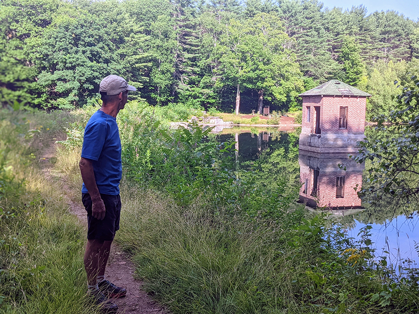
PHOTO: Hart’s Pond is in the center of the Waukewan Highlands Community Park and the Pond was once the public water supply serving Meredith Village. The Town of Meredith has owned this parcel of land since the late 1800’s and continues to manage the land for forestry and recreation. There are three miles of paths–four trails marked with White, Red, Yellow and Blue blazes. From the Trailhead on Parade Road it is an easy walk of less than half a mile to reach the Pond. A trail map and an Interpretive Trail Guide are available to download from the town’s website, MeredithNH.org and click on the Conservation Commission/Hiking Maps.

by Amy Patenaude
Outdoor/Ski Writer
Charlie and I spent the morning blueberry picking and it was a hot day but I still wanted to go for a hike. On our way to Funspot I suggested that we go for a nice little walk first.
Last trip we visited the Laverack Nature Trail at Hawkins Brook right in downtown Meredith. This time I suggested a property even closer to our cool destination–The Waukewan Highlands Community Park. The Park’s parking lot and the trailhead are located at 105 Parade Road.
The Town of Meredith has a bounty of trails on their numerous conservation properties. I often discover hiking trails by searching for the town’s Conservation Commision. Meredith’s Conservation Commission has an excellent web-page with links for their Hiking Maps and Self-guided tours. On their web-page are a list of conservation properties, hiking trail descriptions and maps. Also if you’re interested in volunteering to do trail maintenance there is information about their Tuesday morning work groups.

On their web-page you will find The Waukewan Highlands Community Park map and a colorful and fun guide for their Interpretive Trail System. I pulled the guide up on my phone and we followed it along during our hike.
I read somewhere on their website that the trail system was formed in 1996 but I didn’t learn when the interpretive trail was established. In the northwest corner of the lot there is a kiosk that looks a tad run down. Here a map is posted and information on where to find the Interpretive guide on-line. There are no paper guides in the adjacent mailbox but it is stuffed with lost items and junk. The parking area is well graded and clean and the trails look cared for and are well used.

The Interpretive Trail follows the White, Yellow and Red Trails. Combining the White and Red Trails will make a loop of a distance of one mile. On the White Trail you will see a sign that reads “Jan Pond Way”.
Post “1” had us pretend we were a chipmunk. At post “2” we identified two dead apple trees. I wonder if they were still living when the guide was written. We learned that this now forested land was once an apple orchard.
In just 0.4 miles the White Trail ends at Hart’s Pond and post “4”. It was an easy, fun walk.
From the guide we learned about the Pond. The Pond is small, just three acres and I wondered if it had a natural spring to keep it full? No swimming is permitted but according to the map you can fish. Hart’s Pond was once the water supply for Meredith Village and it remained in service until 1985 when it was replaced by a modern water tower. There is a picnic table here and it is a pleasant place.
At the Pond we had a choice whether to continue on the Yellow Trail for another mile and six more posts or to take the shorter Red Trail back. Since it was hot we chose the shorter route and to skip the middle posts and enjoy the last five.

We followed the path around the pond and admired the reflections of the trees and the old brick pumphouse on its waters. On the Red Trail we hiked uphill away from the Pond. At post “11” we learned about a Check Dam. It’s a pile of rocks in a drainage ditch that acts as a filter to prevent debris from entering the pond. Interesting!
I had to laugh at post “13” as I read it out loud to Charlie, “Wow are you out of breath from walking up that steep hill?” The trail climbed 135 vertical feet and after our nearly flat walk to the Pond we noticed the extra effort.
The forest, the stone walls and Hart’s Pond make this loop a pretty walk and the guide provided interesting and fun facts.
Sometime I’d like to hike the Yellow Trail and follow the rest of the Interpretive Trail. The guide states there is a view of the mountains and of Lake Waukewan along the way. But it has to be a cooler day (Funspot is air conditioned!).
Have Fun.
Amy Patenaude is an avid skier/outdoor enthusiast from Henniker, N.H. Readers are welcome to send comments or suggestions to her at: amy@weirs.com.