Greeley Ponds & K2 Cliff Attempt
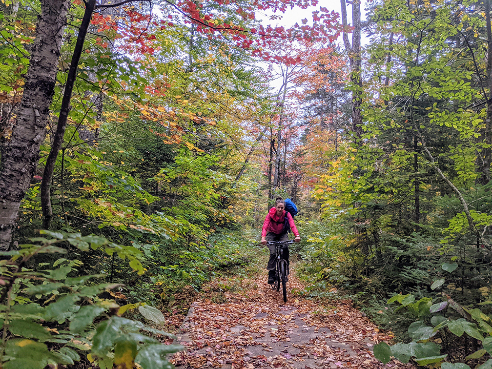
PHOTO: Becca wearing her backpack while mountain biking on the Greeley Pond Trail, Waterville Valley. Fall is a marvelous time to get outdoors because it is still warm, the brightly colored foliage is spectacular and there are no bugs!

by Amy Patenaude
Outdoor/Ski Writer
Greeley Ponds, the headwaters of the Mad River, are located between Mount Osceola and Mount Kancamagus on the floor of Mad River Notch. The Greeley Ponds Trail runs between Waterville Valley and the Kancamagus Highway.
The Greeley Ponds Scenic Area was designated in 1964 to further recognize and protect the beautiful area that has been a popular tourist destination since the mid-1800s. The ponds are named after Nathaniel Greeley, the first Innkeeper in Waterville Valley. In 1860 Greeley built a bridle path from Waterville Valley, past the ponds, making it possible to ride to Mount Washington in a day.
Bridle paths have come and gone but many have endured the test of time as hiking paths. Becca and I began our adventure at the Livermore Road Trailhead. While wearing our backpacks we rode our mountain bikes 3/10th of a mile up Livermore Road and then we continued up the Greeley Pond Trail to the ponds.


In 2011 Tropical Storm Irene wiped out the southern end of the Greeley Ponds Trail and much of it was repaired and relocated. The trail is rather wide and mostly well packed gravel, more like a road than a path, until it reaches the Scenic Area boundary about 3 miles from the Livermore Road Trailhead parking. The Trail to the ponds no longer follows the bank of the Mad River but splits away going more steeply uphill. We were able to ride our bicycles until the point where the trail goes left and a branch of the XC ski trail goes right to Lower Greeley Pond. We ditched our bicycles and hiked a few minutes up the XC ski trail to the pond.
Swirling white clouds gave us glimpses of the wide cliffs on East Osceola and their reflection on the pond’s still waters added to the beautiful scene. The weather forecast was for rain but we were feeling lucky.

Earlier in the week Becca and I thought we’d try to follow the route of a lost rugged path up to K2 cliff, shorthand for Mt. Kancamagus second cliff. In my 1928 White Mountain Guide it’s on the map and has a short mention of a path up to the cliffs beginning from the south end of the lower pond.
We left our big packs behind and we put our rain gear, warm clothes and food and water in my small pack. We gave ourselves an hour as a turn back time. I set my compass bearing and we pushed off through the forest. At times it wasn’t so bad but it was pretty thick with eye poking high young spruce and much of the forest looked like it was a place where Birch trees come to die. The bushwhacking in the trees improved as we got higher but it also got steeper and often we had to go around small cliffs. It was slow going and I wondered out loud if this old path really went to the top of the cliff.

We ended up climbing to an elevation of 3,000 feet, just south of the main cliff. We crossed a scree field that was being taken over by trees and we peered down a long open slab of granite. But we didn’t have much of a view except down to the pond because it was getting more cloudy and dark.
I admitted to Becca that if we climbed up the next obstacle of higher vertical rocks that I didn’t think we’d be able to get back down. Our hour was nearly up anyway so we turned around. We stayed more to the north of our route and we found open woods and we didn’t have to go around so many small cliffs. Our bushwack back down to the pond went much faster.

When we got back to the south end of Lower Greeley Pond we found our packs and took out our packrafts. We inflated them with our battery operated fan-in-the-box. It only took a minute or two and we launched.
Lower Greeley Pond is shallow and thanks to recent rains and the beaver’s dam improvement the pond averaged between a foot and two feet deep. We paddled across the middle of the pond heading north. We got a very good look at what we had climbed. We have both hiked to the summit of Mt. Kancamagus and decided we’d try to reach the K1 Cliff from the top next time. We took out our rafts at the north end, where there is a small beach and a herd path back to the trail. Since it was only 3/10th of a mile to the Upper Greeley Pond we decided to just carry them.
We met two people hiking towards us and they gave us an odd look. We must have been a funny sight while we carried our inflated bright yellow rafts up the trail.
Paddling around Upper Greeley Pond was much different. The water was deep and dark. The water was so high that the beach on the north end was under water. Big rocks lined the shore on the west side and the land went up steeply. Unfortunately, more clouds showed up and it began to rain so we didn’t get to enjoy much of the view.
We carried our rafts back down the trail and then we paddled straight across the Lower Pond. We were soaked to the bone by the time we finished packing up our rafts. Back on our bicycles the rain made it hard to see but this time the bike ride was mostly downhill all the way.
The rain continued as we shoved our bicycles into our cars. It felt wonderful to put on a dry shirt and jacket inside my warm dry car.
Leaf peeping is getting better every day.
Enjoy Fall.
Have Fun.
Amy Patenaude is an avid skier/outdoor enthusiast from Henniker, N.H. Readers are welcome to send comments or suggestions to her at: amy@weirs.com.