On The Appalachian Trail In Maine: 100 Mile Wilderness & Katahdin – Part II
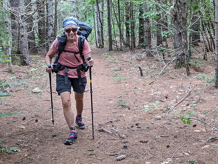
PHOTO: Julie makes good time on a fine example of 2 for 1 Trail! That’s a good trail that you can hike 2 miles with just the effort of a normal 1 mile of Maine Trail. Everyone knows Maine miles are the longest.

by Amy Patenaude
Outdoor/Ski Writer
Click Appalachian Trail Part I to read part one of Amy’s Appalachian Trail trek.
Cooper Brook’s cascading water white noise made for a good night’s sleep for our 4th night sleeping in the 100 Mile Wilderness. We were now halfway through our hike if everything continued to go our way. The hardest part of the 100 Mile Wilderness was now behind us. No more fording big streams and no more big mountains until we reached Katahdin. 58.5 miles were behind us and less than 42 more to go to reach Abol Bridge, the end of the 100 Mile Wilderness.

Day 5. Maybe a dozen or more people had pitched their tents nearby. Many of the thru hikers would be sleeping late in order to continue to enjoy more of Chili P.’s trail magic for breakfast. So we weren’t surprised to see Sunflower at 6:30 am. He had pulled out a chair and was sitting there and said he was waiting for Chili to open at 7 am.
The 2 for 1 miles of trail continued–two miles of trail for the effort of just one Maine mile we often joked. Good thing because now our backpacks were heavier that we had our resupply adding at least a good five pounds of food from our that would have to last until the end of the trip.
The trail felt almost flat. Are we really still going downhill? We hiked effortlessly past brooks and ponds and large White Pines and the Cedar trees. It was another nice day weather wise,sunny and not too hot.
We walked down the short spur to the Antlers Campsite. This is often mentioned by hikers to be a favorite campsite because it is right on the end of Lower Jo-Mary Lake. The morning was still a little hazy and foggy so we didn’t have a big view across the Lake. Just one couple had the site to themselves and they had made themselves right at home and planned to spend a second night here. They were doing a shorter section hike. They told us to watch out that there was a lot of bear poop on the trail ahead of us.
Julie and I had seen a lot of moose poop but no bear scat so far. As we hiked up the trail I noticed a lot of black rotting mushrooms. Aha, those people were convinced that the rotting mushrooms were bear poop! We laughed that the rotting mushrooms had them scared about bears.

We walked, we ate, we walked, we drank water, repeat. That’s hiking. We were loving every minute.
When we reached State Campsite, we reached another milestone, we walked onto the last map of the Maine AT. The guidebook breaks down the Maine AT into 7 maps. We used paper maps all the way. Many hikers use apps on their cellphones but we enjoy the old school paper maps.
As we walked along Nahmakanta Lake, walking past perfectly good campsites that Julie thought looked good but I wanted to make it to Sand Beach. We had such a great time swimming at the last place marked Sand Beach I couldn’t get it out of my head. Of course the flat trail now pulled away from the shore and we had to hike up and down some short but steep hills to reach the north end of the Lake. I felt like a walking Zombie by the time we pitched our tents under some Cedar Trees near the trail and the beach. The swimming was great! 17.4 miles hiked, our longest hiking day of our adventure.
Two Canadians from Nova Scotia were camped on the far end of the beach, they had a picnic table (I was jealous) and a campfire. We chatted while we enjoyed the dry heat of the fire. We learned they planned to summit Katahdin the same day as us.
Again at dusk the thru hikers started filing past us, one told us they all stayed at the trail magic until 10 am. The Loons sang to us all night.

Day 6. Tuesday morning we ate breakfast in orange sunlight as the sun rose across the lake. Soon after leaving Sand Beach we passed by the Wadleigh Stream Lean-to and we were surprised to see so many people there. Many more than the group of thru hikers we had been leap-frogging with on the trail so far.
Two miles into our morning hike we had what felt like a big climb, but it was only 500 vertical feet, Nesutabunt Mountain. Sitting on the summit ledge was a gal with her dog. She was waiting for her friends at the shelter. The morning was clear and we enjoyed a big view of Mount Katahdin. Why did it still look so far away?
After a beautiful morning the clouds began to move in. The sky darkened and we decided we were going to quit at Rainbow Spring Campsite and set up our tents before the rain started. We were the first to stop here because it was only 2 pm. We made great time. 12.3 miles hiked. We picked out good flat spots to pitch our tents. We went swimming. We got water from the spring. We rested and it began to rain at 4 pm.
The Canadians set-up their tents higher on the hill and more than another dozen hikers stopped here too. The good tent sites were gone fast. A big family of 7 with a dog showed up and they spread out. The three daughters sat near the trail in the misty rain and ate. Julie asked me if she could move her tent tightly next to mine and give up her spot to the girls. The girls thanked Julie and were happy to accept the offer. In the morning the girl’s mother thanked Julie for her kindness for making room for her girls. (Later we found out this was the Bennet family, KidsOutWild, and they were on their way to completing the Triple Crown-the AT, PCT and CDT).
We then saw just two of the Maine Men and chatted with them. Sadly the third had slipped and torn his calf muscle and had left the trail; his wife picked him up at a logging road crossing. Our hearts sank. They told us they were calling it quits at Abol bridge and would resume their section hike together next year. They pushed on up the trail and we never saw them again.
We had met so many nice people. Short conversations with people attempting the same thing create a trail bond. Everyone doesn’t get to finish.
Day 7. After heavy rain during the night we packed up our wet and muddy tents and hit the trail again in the misty rain. By the time we reached the open Rainbow Ledges the sun was shining bright again. We took our tents out of our packs to allow them to dry. We had an extra long second breakfast.
The miles flew by and we popped out onto the Golden Road and neared Abol Bridge. Wow we made it and it was only 12:30. 11.3 miles hiked.
We went straight to the Abol Bridge Family Campground & restaurant. The Canadians were at the counter enquiring about a campsite. I asked about the cabins and did the math quickly that it was only ten dollars more per person to have a cabin and it included breakfast at 7:30. The Canadians, Shane and Andrew rented a cabin too.
In a flash Julie and I hiker-trashed the cabin. Every item we carried now was spread out on the bunk beds and floor. We hung our tents on the nearby trees to dry and aired out our sleeping bags.
During the night the wind blew hard and the temperature dropped into the 40s. Being inside a cabin was a good thing.

Day 8. Our march to the Katahdin Stream Campground was just under ten miles. We recognized many of the dozen or so hikers standing outside the store waiting like us for the doors to open for breakfast. We listened as people talked about signing up for the hiker’s campsite at the Birches at 6 am at the Baxter State Park boundary kiosk.
They had already raced a mile before breakfast.
The breakfast at the campground had decent coffee, okay eggs and tasty biscuits and gravy. This was the first day we didn’t hike in shorts, it was chilly.
The hike along the Nesowadnehunk Stream was beautiful. At first it was wide and smooth, a favorite place for people to float in the river. As we walked upstream it got narrower and more cascades and rocks appeared. We checked out the lovely waterfalls of Big and Little Niagara Falls–a favorite day hike destination for Baxter State Park Campers staying at Daicey Pond.
We were excited to get to the trailhead to Mount Katahdin. We registered at the Ranger Station and received our AT hiker permit. We learned the campsite I had reserved was as far away from the Rangers Station and the bag hang (a flagpole with cables rigged to keep our food away from the animals by hanging it high).
We mingled with other AT hikers around a small campfire near the Ranger’s Station. The topic of conversation was the weather. Today many people had turned back on their attempt because the winds were high and rime ice covered the trail above the treeline. Everyone hoped for a better day tomorrow.

Day 9. We were headed up the trail at 6:30 am, a little earlier than we had planned but we were ready to go. Our packs were nearly empty, only food, essentials and our warm clothing. We left everything else at the AT hiker lean-to at the Ranger Station–no need to lug our tents and sleeping bags back up and down the mountain. It was almost 3 miles to the treeline and then more than 2 above it to reach the summit.
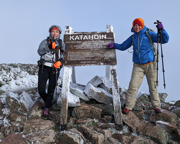
Julie and I have summited Katahdin before but we’d never gone up the Hunt Trail. Walking the last miles to the northern terminus and leapfrogging with thru-hikers that were on their way to finishing their 2,000 mile journey was an emotional and inspirational experience. The rock scrambling wasn’t easy with the ice and wind. It wasn’t bad but challenging and cold.
We could only see a couple hundred feet ahead of us while in the clouds. The wind was strong, we wore every piece of clothing we brought along. Hats, gloves, down puffy jackets covered by our rain jackets to block the wind. Many others had no hats or gloves or even a warm jacket as they pushed through the cold. Heck it was September 16th and wasn’t global warming supposed to be keeping us warm up here? On the summit we snapped photos of hikers posing and climbing on the iconic wood summit sign and then we watch them run back down the trail.

Julie noticed first that the clouds broke and we all could see down the Knife Edge to South Peak and down to the lakes below. The view lasted only a few seconds but we all were in awe.
We spent 20 minutes on the summit, much longer than anyone else. We watched our Canadian friends summit. The previous night we learned we’d be sharing the shuttle back to 100 Mile Wilderness Adventures with them.
On our return we experienced a few more moments when the clouds parted and we could see across the tablelands to the surrounding peaks in the Park.
At Thoreau’s Spring, truly just a mud hole, we took a left and headed down the Abol Trail. We decided we wanted to see more of Baxter State Park and this was a new-to-us-trail. It follows the Abol Slide and then where the slide gets unstable the trail is routed to the side with wonderful switchbacks and stone step stairways. We had this trail all to ourselves and it felt wild. We watched the clouds dance over the ridge the Hunt Trail follows.
It didn’t take long for us to get below the clouds and into the sunshine. We enjoyed our last hours on the mountain very much. We took our time and a few snack breaks and enjoyed the now wide open vista. The Abol Trail was very steep but had much less boulder and rock climbing than the Hunt Trail.
Before 2pm, on the Tote Road in front of the Abol Campground, the very first car that came by gave us a ride. It was nice not to have to road-walk 2 miles back to the Katahdin Stream Campground.
We gathered our things at the AT hiker lean-to and we sat on the lawn in the sun. Shane and Andrew joined us as we waited. Phil was early and we quickly tossed everything in the back of his SUV. During our ride out of the park we told our stories of our day’s adventure.
Phil pulled into the Millinocket General Store and we rushed the place to buy food and drinks we had missed on the trail.

The hot shower and putting on the clean clothing we had waiting in my car never felt so good. It was the first hot shower and clean clothes that we had had in 9 days! We were happy to be back in our Cabin at 100 Mile Wilderness.
Of course we all went out to supper at the Lakeshore House & Pub in Monson. It was the first time we had gone to bed after 7pm in nine days.
Completing the 100 Mile Wilderness and the Maine section of the Appalachian Trail was a goal I have been working on for a long time. How things went together the last couple years made my sweet dreams come true.
I’d like to thank my hiking pal Julie for sharing this journey with me, it was a lot of fun. Maybe we should go to Georgia next Spring?
Have fun.
Amy Patenaude is an avid skier/outdoor enthusiast from Henniker, N.H. Readers are welcome to send comments or suggestions to her at: amy@weirs.com.