
Hiking The Georgiana Falls Path – Lincoln, New Hampshire
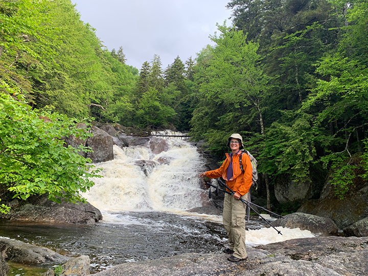
PHOTO: On The Trails & Summits columnist Amy Patenaude standing at the edge of the Lower Georgiana Falls pool. The lower falls are 30 feet high and almost as wide. Lower Georgiana Falls is a nice place anytime of year or weather. During times of high water the loud roar of the cascading water is soothing. During hot weather sunbathing and wading in Harvard Brook is a cool thing to do. The Georgiana Falls Path is located in Lincoln, NH and a full trail description can be found in the AMC’s White Mountain Guide.

by Amy Patenaude
Outdoor/Ski Writer
After all this rain we decided a fun thing to do would be to hike to a roaring waterfall. Rain was still in the forecast. So we chose to hike the Georgiana Falls Path along Harvard Brook because of its continuous lovely cascading waters between the lower and upper waterfalls.
To find the Georgiana Falls Path from the south bend on Hanson Farm Road (a quarter mile north of I-93’s exit 33 on the westside of Route 3) where a sign reads, “road is not maintained”, continue straight ahead to a parking area.
Harvard Brook runs through the Second Presidential State Forest and the path to the falls is not an officially maintained trail. I think this is odd because it is a well used path and I recently noticed that a photo from the upper falls is being used in a NH tourist advertisement.
Becca, Bria and I met in the parking area. The falls are so nice both Becca and I have been here a few times. This path is described in the AMC White Mountain Guide and this would count towards Bria’s redlining of the guidebook. It was misty and warm and then the weather started to clear so we happily shed our rain jackets.


We hiked up the snowmobile/path underneath the northbound lanes of I-93. At the fork we went right, following the instructions from a small white homemade sign with an arrow pointing to Georgiana Falls. The other signs here pointing straight ahead are for the snowmobile trails.
Then we soon crossed underneath I-93 southbound and soon the path heads left off the old road. The path is well blazed and the footbed is very well worn. You’d have to try to get lost here but please don’t.
It is only about three quarters of a mile to reach the lower falls. The pool beneath it didn’t look like a pool on this day because the brook was running high and fast. The path wanders away from the brook at times but you will certainly know when you reach the lower falls. The brook’s waters fall down over a large open ledgy area into a big pool. Many people end their hike here.
Often the roar of the water was so loud we had trouble hearing unless we were standing right next to one another. I really like the sound of the cascading water.

It is about another half a mile from the lower falls to reach the upper falls and the path continues steeply and is challenging. The path is blazed but people have made paths all over the place to avoid blown down trees and steep rocks. Sometimes Bria and Becca decided to go a different route than I was taking. We did take our time hiking to make sure we had good footing since it was slippery from the rain.
We chose to stay close to the brook nearer the side of the waterfall. We followed the path right to the top of the upper falls. We couldn’t reenact the advertisement because if we had tried to step into the water above the falls the rapid water would have swept us away.
Hiking back down the path was not easier. Maybe it wasn’t as strenuous going downhill but trying not to slip took a lot of effort.
While we made our way down we passed by several people and their well behaved dogs making their way up the path.
Back at the car we stopped our trackers and mine read 2.8 miles and 830 vf of climbing in less than two hours. I guess I did a lot of trips back and forth to the brook to add another third of a mile to the hike.
Bria thanked us for joining her for her redline before she headed home. Becca and I had our packrafts with us so we decided to bounce down a few sections of the upper Pemigewasset River after a lot of scouting.
It is a wild place.
Have Fun.
Amy Patenaude is an avid skier/outdoor enthusiast from Henniker, N.H. Readers are welcome to send comments or suggestions to her at: amy@weirs.com.


